Archive
New Zealand Earthquakes 2013: Temblors Damage Homes And Destroy Bridge
 WELLINGTON, New Zealand — Strong earthquakes shook central New Zealand on Friday, damaging homes and roads and sending office workers scrambling for cover in the capital. No serious injuries were reported.
A magnitude-6.5 temblor struck just after 2:30 p.m. near the small South Island town of Seddon, and at least six aftershocks were 5.0 magnitude or stronger.
Several homes near the epicenter were severely damaged, with chimneys collapsing and roofs caving in, said police spokeswoman Barbara Dunn. She said a bridge was severely damaged on the main highway near Seddon, and that rocks and debris had fallen onto the road. Police closed a section of the highway.
Some buildings in Wellington, the capital, were evacuated, and items were knocked off shelves in places.
Police said a number of people were freed from Wellington elevators that stopped working. The initial temblor also forced the nation’s stock exchange to close for more than an hour.
Wellington Mayor Celia Wade-Brown said there was Read more…
Giant Blob At Earth’s Core Will Cause Most Cataclysmic Kind Of Volcanic Eruption Says Utah Seismologist
nanopatentsandinnovations.blogspot.com
A University of Utah seismologist analyzed seismic waves that bombarded Earth’s core, and believes he got a look at the earliest roots of Earth’s most cataclysmic kind of volcanic eruption. But don’t worry. He says it won’t happen for perhaps 200 million years.
“What we may be detecting is the start of one of these large eruptive events that – if it ever happens – could cause very massive destruction on Earth,” says seismologist Michael Thorne, the study’s principal author and an assistant professor of geology and geophysics at the University of Utah.
But disaster is “not imminent,” he adds, “This is the type of mechanism that may generate massive plume eruptions, but on the timescale of 100 million to 200 million years from now. So don’t cancel your cruises.” This map shows Earth’s surface superimposed on a depiction of what a new University of Utah study indicates is happening 1,800 miles deep at the boundary between Earth’s warm, rocky mantle and its liquid outer core. Using seismic waves the probe Earth’s deep interior, seismologist Michael Thorne found evidence that two continent-sized piles of rock are colliding as they move atop the core. The merger process isn’t yet complete, so there is a depression or hole between the merging piles. But in that hole, a Florida-sized blob of partly molten rock – called a “mega ultra low velocity zone” – is forming from the collision of smaller blobs on the edges of the continent-sized piles. Thorne believe this process is the beginning stage of massive volcanic eruptions that won’t occur for another 100 million to 2100 million years.

Photo Credit: Michael S. Thorne, University of Utah
The new study, set for Read more…
7.5-magnitude earthquake strikes southeast of Alaska
The U.S. Geological Survey (USGS) said that a strong 7.5-magnitude earthquake struck off the southeastern coast of Alaska just before midnight local time last night (January 4-5, 2013). A local tsunami warning was issued for parts of southern Alaska and coastal Canada, and it has now been withdrawn. The warning area extened for about 475 miles and included coastal areas from about 75 miles southeast of Cordova, Alaska, to the north tip of Vancouver Island, Canada, the Alaska Tsunami Warning Center said. There were no initial reports of damage from the earthquake.
Here are the details of the quake from USGS:
Date-Time Saturday, January 05, 2013 at Read more…
The Ring Of Fire Is Roaring To Life And There Will Be Earthquakes Of Historic Importance On The West Coast Of The United States
 Does it seem to you like there has been an unusual amount of seismic activity around the world lately? Well, it isn’t just your imagination. The Ring of Fire is roaring to life and that is really bad news for the west coast of the United States. Approximately 90 percent of all earthquakes and approximately 75 percent of all volcanic eruptions occur along the Ring of Fire. Considering the fact that the entire west coast of the United States lies along the Ring of Fire, we should be very concerned that the Ring of Fire is becoming more active. On Wednesday, the most powerful strike-slip earthquake ever recorded happened along the Ring of Fire. If that earthquake had happened in a major U.S. city along the west coast, the city would have been entirely destroyed. Scientists tell us that there is nearly a 100% certainty that the “Big One” will hit California at some point. In recent years we have seen Japan, Chile, Indonesia and New Zealand all get hit by historic earthquakes. It is inevitable that there will be earthquakes of historic importance on the west coast of the United States as well. So far we have been very fortunate, but that good fortune will not last indefinitely.
In a previous article, I showed that earthquakes are becoming more frequent around the globe. In 2001, there were 137 earthquakes of magnitude 6.0 or greater and in 2011 there were 205. The charts and data that I presented in that previous article show a clear Read more…
Strong 6.0 earthquake strikes off Oregon coast
 Feb 14 (Reuters) – A strong 6.0 magnitude earthquake
struck on Tuesday roughly 160 miles off the coast of Oregon, the
U.S. Geological Survey said.
The quake struck at 7:31 p.m. Pacific time at a depth of 6.2
miles in the Pacific Ocean 159 miles west of Coos Bay, Oregon.
It was felt as far away as San Francisco, California, according
to the USGS.
A spokesman for the Portland police said he did not feel the
quake. There were immediate reports of damage or injuries.
No tsunami warning was issued by the Pacific Tsunami Warning
Center.
6.8 earthquake shakes central Philippines; 1 dead
 MANILA, Philippines: A 6.8-magnitude earthquake struck the central Philippines on Monday, killing a child and triggering a local tsunami alert.
The Philippine Institute of Volcanology and Seismology issued the tsunami alert for the central Philippines, saying the quake, which hit in a narrow strait just off Negros Island, could trigger a 3-foot (1-meter) wave along the island’s eastern coast as well as west of Cebu City, the country’s second largest.
The Pacific Tsunami Warning Center did not issue a wider regional warning.
The U.S. Geological Survey said the quake was centered 44 Read more…
2/2/2012 — 6.9 magnitude earthquake north of New Zealand — Vanutau
The Coming Apocalypse: The Pacific Ring of Fire has been Heating up over the last Two Years
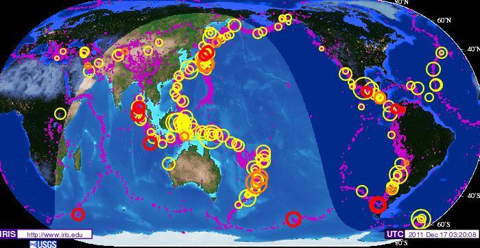
For those following earth changes for their relevance to the coming of the Messiah, here are two charts to comprehend. Both are IRIS maps published by the United States Geological Services. What is most important is to notice the dates of each map, and then begin to analyze the finer data that is including in regard not just to large earthquakes but most important to the flurries of smaller quakes (purples dots) that are caused by ‘Planet Earth rocking and rolling’ as it is buffeted by the strong electromagnetic force field of Nibiru, the Dark Twin Binary Brown (Red) Star that is returning as our Sun’s Twin Solar System as an emissary of G-d’s divine judgment.
The IRIS Earthquake map below shows the number of quakes on Planet Earth for a 5 year historical period between the years of January 20, 2004 to January 20, 2009. The IRIS Earthquake map above depicts the number of earthquake for only 2 year historical period between the dates of January 9, 2009 and December 17, 2011.
Take a close look and consider what is visibly obvious of how the number of large earthquakes have become more numerous and intensive in magnitude in the Read more…
Magnitude 5.1 – FOX ISLANDS, ALEUTIAN ISLANDS, ALASKA

Chile Earthquake Strikes Today: Panic Felt
 Only yesterday we reported on an earthquake in Mexico and earlier today about another earthquake in Hawaii. A further earthquake has now been reported off the coast of Chile with a magnitude of 6.2. There are no reports yet of any people injured or damage but the quake did cause panic.
The quake happened at 1:04 pm local time, that’s 4:04 pm UTC or 11:04 am EST at a depth of 18.5 miles (29.7 km). According to the USGS the epicenter was 31 miles (50 km) north of Concepcion, Bio-Bio, Chile, 49 miles (80 km) southwest of Cauquennes, Maule, Chile, 55 miles (90 km) west-northwest of Chillan, Bio-Bio, Chile or 244 miles (393 km) south-southwest of Santiago, Chile.
The national emergency office of Chile said no immediate reports had come in about injuries. A tsunami warning was not issued. The effects of today’s temblor were widely felt though Read more…

![[Most Recent Quotes from www.kitco.com]](https://i0.wp.com/www.kitconet.com/charts/metals/gold/t24_au_en_usoz_2.gif)
![[Most Recent Quotes from www.kitco.com]](https://i0.wp.com/www.kitconet.com/charts/metals/silver/t24_ag_en_usoz_2.gif)


You must be logged in to post a comment.