Archive
Giant Blob At Earth’s Core Will Cause Most Cataclysmic Kind Of Volcanic Eruption Says Utah Seismologist
nanopatentsandinnovations.blogspot.com
A University of Utah seismologist analyzed seismic waves that bombarded Earth’s core, and believes he got a look at the earliest roots of Earth’s most cataclysmic kind of volcanic eruption. But don’t worry. He says it won’t happen for perhaps 200 million years.
“What we may be detecting is the start of one of these large eruptive events that – if it ever happens – could cause very massive destruction on Earth,” says seismologist Michael Thorne, the study’s principal author and an assistant professor of geology and geophysics at the University of Utah.
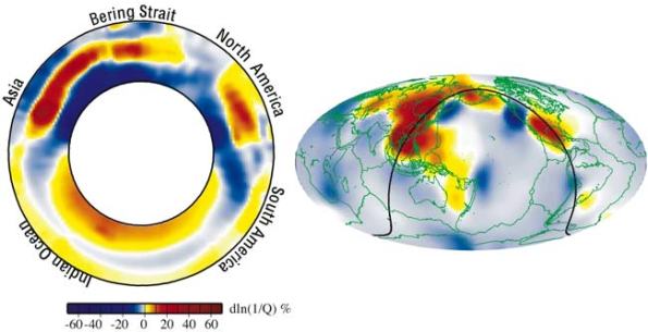
But disaster is “not imminent,” he adds, “This is the type of mechanism that may generate massive plume eruptions, but on the timescale of 100 million to 200 million years from now. So don’t cancel your cruises.” This map shows Earth’s surface superimposed on a depiction of what a new University of Utah study indicates is happening 1,800 miles deep at the boundary between Earth’s warm, rocky mantle and its liquid outer core. Using seismic waves the probe Earth’s deep interior, seismologist Michael Thorne found evidence that two continent-sized piles of rock are colliding as they move atop the core. The merger process isn’t yet complete, so there is a depression or hole between the merging piles. But in that hole, a Florida-sized blob of partly molten rock – called a “mega ultra low velocity zone” – is forming from the collision of smaller blobs on the edges of the continent-sized piles. Thorne believe this process is the beginning stage of massive volcanic eruptions that won’t occur for another 100 million to 2100 million years.

Photo Credit: Michael S. Thorne, University of Utah
The new study, set for Read more…
Seismic activity rose, then dropped after ‘burp’
Associated Press
BAYOU CORNE — Scientists have noticed a recent increase in seismic activity near the 8.5-acre sinkhole at Bayou Corne, and worry that it might grow again, Assumption Parish officials say.
The increase was first noticed about two weeks ago, John Boudreaux, director of the Assumption Parish Office of Homeland Security and Emergency Preparedness, said.
Scientists noticed more than 80 such events on Friday, but activity dropped after the sinkhole “burped” crude oil, debris and Read more…
Russia: “4 Hectares of New Land Emerged, from the Shift of Tectonic Plates”
Apologies to Alexsandr, from whose Q to the Z’s on the 9/3 Q & A Chat I borrowed this. I feel this deserves a blog post. Land appearing virtually overnite from admitted plate activity. This is just more proof of Planet X’s influence, IMO.
Below a Google translation of a report, source of which, including video, here.
Amazing natural phenomenon has been documented in recent days. Huge beds of clay and stone rose by about 5 meters above the Sea of Azov in the Temryuk district of Krasnodar region, forming a peninsula.
Scientists suggest that the cause of the “new lands” have awakened mud volcanoes, and seismologists have Read more…
Huge ‘Ocean’ Discovered Inside Earth
This article was published a few years back but it is still very interesting.
 Scientists scanning the deep interior of Earth have found evidence of a vast water reservoir beneath eastern Asia that is at least the volume of the Arctic Ocean.
The discovery marks the first time such a large body of water has found in the planet’s deep mantle.
The finding, made by Michael Wysession, a seismologist at Washington University in St. Louis, and his former graduate student Jesse Lawrence, now at the University of California, San Diego, will be detailed in a forthcoming monograph to be published by Read more…
Ancient faults still prove to be powerful
“Our discussion was interrupted,” Department Chair Chuck Bailey said, “by a motion from the floor.”
All joking aside, even the experts didn’t realize what was going on at first.
“We thought it was construction,” Chancellor Professor of Geology Heather Macdonald said.
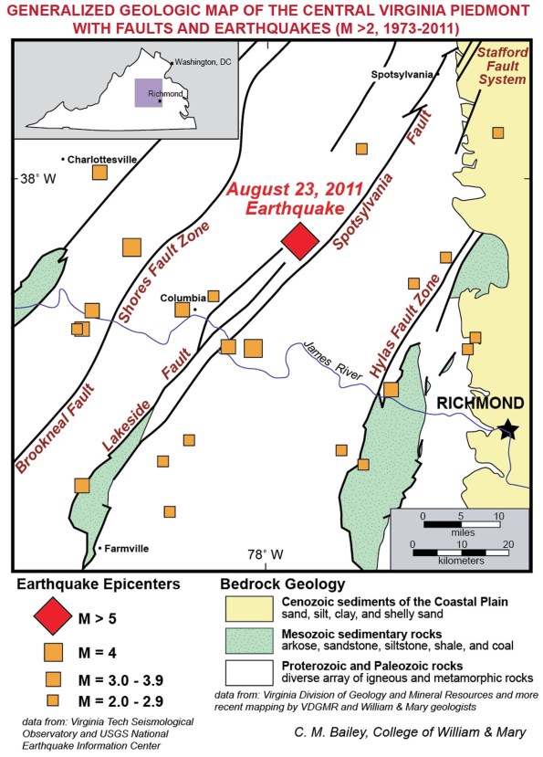
However, when the tremor continued for nearly 20 seconds the geologists realized they had a quake on their hands – a major quake. A 5.8 on the Richter scale is significant for the region.
According to reports, the earthquake occurred at 1:51 p.m. and was centered in Mineral, Va., which is about half way between Richmond and Charlottesville. Tremors were felt as far north as Maine.
Bailey, a structural geologist who teaches courses on Virginia geology, is particularly familiar with the area’s seismic activity. Following Tuesday’s event, his expertise was sought out by national and local media.
“This is a once-in-a-century earthquake, anyway you slice it”, Bailey told the Associated Press, adding that quakes of a similar Read more…
China quake measuring 5.8 leaves 26 injured
Beijing: Twenty-six people were injured, three of them critically, and a number of houses damaged when a 5.8-magnitude earthquake on Thursday hit northwest China, the official media said.
The epicentre of the quake was at the border area between the region’s Atux City in the Kizilsu Kirgiz Autonomous Prefecture and Jiashi County in Kashghar, state news agency Xinhua reported.
The quake that struck Xinjiang Uygur Autonomous Region occurred at 6:06 pm local time, the China Earthquake Networks Center said.

It has also toppled more than 30 units of housing, according to a spokesman with the Jiashi County Committee of the Communist Party of China.
Two days ago three persons were injured and more than 40,000 people affected when a 5.2-magnitude earthquake hit southwest Yunnan Province.
6.0 Quakes Every Day, California Swarms
Ring of Fire: Update
Labor market risks of a magnitude 7.8 earthquake in southern California
PDF file of this Regional Report | Other BLS Regional Reports
Authors:
Richard Holden, Amar Mann, and Tian Luo
Bureau of Labor Statistics Read more…
More Than 720 Earthquakes Recorded On El Hierro In One Week
An unprecedented 720 earthquakes have been recorded on El Hierro, the smallest of the Canary Islands, during the past week.
The earthquake swarm has even prompted the Canary Islands Government to convene the first ever meeting of the Steering Committee and Volcanic Monitoring, reflected in the Specific Plan Protection Civil and Emergency for Volcanic Risk, given what it described “the significant increase in seismic activity”.
The National Geographic Institute (IGN) and Volcanological Institute of the Canary Islands is continuing to record scores of earthquakes, measuring between 1 and 3 on the Richter Scale, each day. The majority of earthquakes are being recorded at a depth of between 5km and 15 km.
According to Actualidad Volcánica de Canarias (AVCAN), the vast majority of the tremors have Read more…
Powerful Shallow Earthquake Hits Gulf Of California
The Gulf of California, a body of water that separates the Baja California Peninsula from the Mexican mainland, was struck by a powerful shallow earthquake Tuesday morning.
The 5.8 magnitude quake struck at 11.44a.m. local time. The epicentre was situated 86 km (53 miles) southwest of Los Mochis, Sinaloa; 138 km (85 miles) north-northeast of La Paz, Baja California Sur; and 142 km (88 miles) west-southwest of Guamuchil, Sinaloa (Mexico).
The US Geological Survey (USGS) measured the seaquake depth at Read more…


![[Most Recent Quotes from www.kitco.com]](https://i0.wp.com/www.kitconet.com/charts/metals/gold/t24_au_en_usoz_2.gif)
![[Most Recent Quotes from www.kitco.com]](https://i0.wp.com/www.kitconet.com/charts/metals/silver/t24_ag_en_usoz_2.gif)

You must be logged in to post a comment.