Archive
Hawaii scientists monitor earthquake swarm near Kilauea volcano
48 small quakes and counting on the Big Island as of Wednesday morning
HAWAII VOLCANOES NATIONAL PARK, Hawaii: Scientists at the USGS Hawaiian Volcano Observatory are keeping an eye on a swarm of small earthquakes around the active Kilauea volcano.
In its morning status report, HVO wrote that there “is an ongoing seismic swarm just northwest of the summit.”
From the Wednesday status report, updated at 7:29 HST:
A swarm of shallow earthquakes started after midnight last night about 5 km (3 mi) northwest of Halema`uma`u Crater that was ongoing as of this posting. Forty-eight earthquakes were strong enough to be located beneath Kilauea: 39 quakes within the Read more…
Scientists eye threat of Pacific Northwest megaquake

Scientists used a supercomputer-driven "virtual earthquake" to explore likely ground shaking in a magnitude 9.0 megathrust earthquake in the Pacific Northwest. Peak ground velocities are displayed in yellow and red. The legend represents speed in meters per second (m/s) with red equaling 2.3 m/s. Although the largest ground motions occur offshore near the fault and decrease eastward, sedimentary basins lying beneath some cities amplify the shaking in Seattle, Tacoma, Olympia, and Vancouver, increasing the risk of damage. (Credit: Kim Olsen, SDSU)
EWA BEACH (HawaiiNewsNow) – Scientists say there are parallels between recent earthquakes and ground movement in the Pacific Northwest and what happened in Japan before last year’s devastating quake and tsunami.
The research was discussed over the weekend at the annual meeting of the American Association for the Advancement of Science. Scientists at the Pacific Tsunami Warning Center in Ewa Beach are well aware of the new research.
The disaster in Japan occurred because of stress from the Pacific tectonic plate sliding below Japan. The plates locked together, slowly pushing Japan westward, and then released, resulting in the magnitude 9.0 earthquake and tsunami that killed thousands. Japan moved about ten to 15 feet eastward in the quake.
Scientists said the same thing is now in the works off the coast of British Columbia, Washington and Oregon, as the Juan de Fuca plate moves beneath the Pacific Northwest.
“The Pacific Northwest is being deformed because the plates are locked together, and the shoreline is sinking and the rest of the thing is being bent. We can see that,” said Dr. Gerard Fryer, a geophysicist with the warning center. “It’s just like Japan, only a mirror image.”
According to Fryer, the last big earthquake in the Pacific Northwest happened in January 1700. Like the Japan quake, it also was a magnitude 9.0, and sent a destructive Pacific wide tsunami that reached Japan.
While there has been more ground movement in the northwest, there’s still the question of Read more…
Missouri 4.0 earthquake felt across 13 states
 SIKESTON, Mo. – A magnitude 4.0 earthquake struck early Tuesday in the southeast corner Missouri, waking up residents in as many as 12 other surrounding states.
The US Geological Survey (USGS) said the quake hit at 3:58am local time (4:58am ET). Its epicenter was located a shallow 3.1 miles (5km) underground, about 150 miles (240km) south of St. Louis, near the New Madrid fault line.
Outside of Missouri, the temblor was felt in Illinois, Tennessee, Kentucky, Arkansas and Indiana. Residents also reported feeling the ground shake in Alabama, Georgia, North Carolina, Pennsylvania, Wisconsin, Kansas and Oklahoma.
Save for a few reports of items falling off shelves and windows cracking, the rumbling caused no real damage.
But experts said it serves as an important reminder of Read more…
Strong 6.0 earthquake strikes off Oregon coast
 Feb 14 (Reuters) – A strong 6.0 magnitude earthquake
struck on Tuesday roughly 160 miles off the coast of Oregon, the
U.S. Geological Survey said.
The quake struck at 7:31 p.m. Pacific time at a depth of 6.2
miles in the Pacific Ocean 159 miles west of Coos Bay, Oregon.
It was felt as far away as San Francisco, California, according
to the USGS.
A spokesman for the Portland police said he did not feel the
quake. There were immediate reports of damage or injuries.
No tsunami warning was issued by the Pacific Tsunami Warning
Center.
California Earthquake: Officials Warn Of Aftershocks After 5.6 Magnitude Quake Rocks Northern Coast
A 5.6 magnitude earthquake rocked the Northern California coast Monday afternoon, yielding no immediate injuries or damage but prompting warnings of several aftershocks throughout the week.
According to the U.S. Geological Survey, the earthquake struck around 1:07 p.m. about 18 miles inland in Humboldt County.

A 5.6 magnitude earthquake rocked the Northern California coast Monday afternoon, yielding no immediate injuries or damage but prompting warnings of several aftershocks throughout the week. The quake, which struck around 1:07 p.m., had its epicenter in a rural area near Weitchpec on the Hoopa Valley Indian Reservation.
Its epicenter was a rural area near Weitchpec on the Hoopa Valley Indian Reservation. The reservation is about 240 miles north of San Francisco, and 60 miles south of the Oregon-California border.
The Northern California quake was widely felt within a 100-mile radius, according to the USGS web site. The depth of the earthquake was roughly 20.4 miles.
‘You have no control of these things.’
The Humboldt County Sheriff’s Department and Eureka Police Department sent officials to check on residents, but dispatchers said there were Full article here
2/10/2012 — MUST SEE ! 2011 earthquakes WORLDWIDE plotted and animated (with sound intensity) !
This is truly profound to see — the year of 2011 earthquakes plotted out on a orthographic (globe) map — ANIMATED WITH SOUND INTENSITY for each earthquake!!
many thanks to youtube user : oilcansam for informing me of this..
and even MORE thanks to:
http://monoroch.net/jishin2011/
original video uploaded with hattip and permission request:
6.8 earthquake shakes central Philippines; 1 dead
 MANILA, Philippines: A 6.8-magnitude earthquake struck the central Philippines on Monday, killing a child and triggering a local tsunami alert.
The Philippine Institute of Volcanology and Seismology issued the tsunami alert for the central Philippines, saying the quake, which hit in a narrow strait just off Negros Island, could trigger a 3-foot (1-meter) wave along the island’s eastern coast as well as west of Cebu City, the country’s second largest.
The Pacific Tsunami Warning Center did not issue a wider regional warning.
The U.S. Geological Survey said the quake was centered 44 Read more…
Haiti, Dominican Republic May Be Entering Big Earthquake Period
 Haiti and the neighboring Dominican Republic could be in for a period of periodic powerful earthquakes, according to a recent scientific study.
The study says Haiti’s 7.0-magnitude earthquake two years ago is likely to be the first of several quakes of a similarly powerful magnitude.
The Jan. 12, 2010, earthquake caused widespread damage in the Haitian capital and surrounding cities. Officials say the disaster killed 314,000 people and toppled thousands of crudely built homes.
“The 2010 Haiti earthquake may mark the beginning of a new cycle of large earthquakes on the Enriquillo fault system after 240 years of seismic quiescence,” lead author William Bakun of the U.S. Geological Survey wrote. “The entire Enriquillo fault system appears to be Read more…
2/2/2012 — 6.9 magnitude earthquake north of New Zealand — Vanutau
The Coming Apocalypse: The Pacific Ring of Fire has been Heating up over the last Two Years
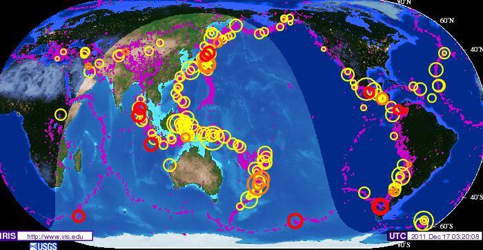
For those following earth changes for their relevance to the coming of the Messiah, here are two charts to comprehend. Both are IRIS maps published by the United States Geological Services. What is most important is to notice the dates of each map, and then begin to analyze the finer data that is including in regard not just to large earthquakes but most important to the flurries of smaller quakes (purples dots) that are caused by ‘Planet Earth rocking and rolling’ as it is buffeted by the strong electromagnetic force field of Nibiru, the Dark Twin Binary Brown (Red) Star that is returning as our Sun’s Twin Solar System as an emissary of G-d’s divine judgment.
The IRIS Earthquake map below shows the number of quakes on Planet Earth for a 5 year historical period between the years of January 20, 2004 to January 20, 2009. The IRIS Earthquake map above depicts the number of earthquake for only 2 year historical period between the dates of January 9, 2009 and December 17, 2011.
Take a close look and consider what is visibly obvious of how the number of large earthquakes have become more numerous and intensive in magnitude in the Read more…

![[Most Recent Quotes from www.kitco.com]](https://i0.wp.com/www.kitconet.com/charts/metals/gold/t24_au_en_usoz_2.gif)
![[Most Recent Quotes from www.kitco.com]](https://i0.wp.com/www.kitconet.com/charts/metals/silver/t24_ag_en_usoz_2.gif)


You must be logged in to post a comment.