Archive
Floods spread GM seed

Bob Mackley, who farms at Duchembegarra, north of Natimuk, said his paddocks have been over-run by genetically modified canola following summer flooding in the Wimmera.
A WIMMERA farmer whose paddocks have been infested by genetically modified (GM) canola washed down by the December floods says the spread of large chunks of GM seed highlights the inadequacy of Australia’s co-existence policy between GM and non-GM canola.
Bob Mackley, who farms at Duchembegarra, north of Natimuk, said measures such as adventitious presence (AP) levels of trace levels of GM material were designed for contamination by cross-pollination, not for the widespread transportation of viable seed pods.
“The canola was transported in the first floods, then when we got the rain in January, it germinated quite a substantial amount.
“I’d say it could easily be more than the prescribed levels of 0.9pc GM material.”
However, Monsanto corporate affairs lead Keryn McLean said Mr Mackley needed only to approach the GM canola volunteers as any other weed.
“For any farmer intending to plant a crop this season, it is best practice to control weeds in paddocks prior to sowing any seed, canola or otherwise,” she said.
“If Roundup Ready canola was transferred into the paddock, a number of other plants would Read more…
Flood-hit town sees off Dianne but Carlos is on the horizon
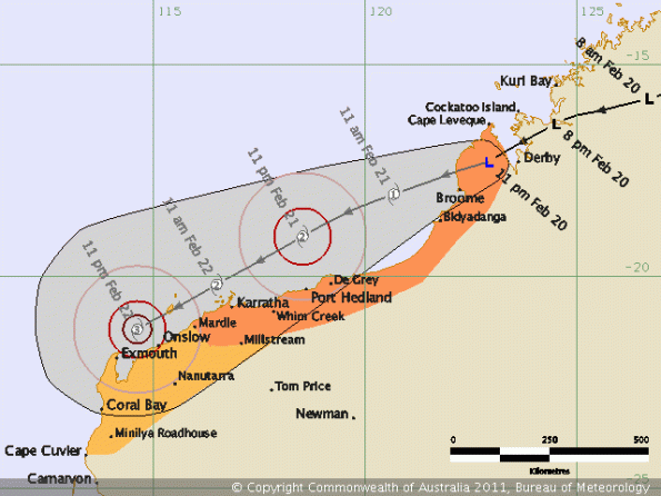
HARD-HIT residents of Western Australia’s northern Gascoyne region are bracing for more floods after high river levels left a family stranded and crops damaged on the weekend.
 At Carnarvon, 910km north of Perth, the river’s peak was among the highest ever recorded on Saturday because of rain from Cyclone Dianne.
This week, the town is expected to be affected by a re-formed Cyclone Carlos.
On Saturday, the Gascoyne River peaked at 7.1m, leaving one family with two small children stranded on its north side.
Fire and Emergency Services Authority media liaison officer Brian Halberg said the family had been evacuated by emergency workers and their home was undamaged by the floodwaters.
Flooding was much Read more…
How Cyclone Yasi compares in size to countries

Date/Time: 2011:02:02 13:29:18 Source: news.com.au
IF you’re struggling to grasp the magnitude of Tropical Cyclone Yasi, consider this: it is so large it would almost cover the United States, most of Asia and large parts of Europe.
Most of the coverage about the scale of Yasi has tried to compare it with storms of the past – it’s bigger than Larry, more powerful than Tracy.
But just as powerful is this comparison, showing this storm is continental in size. The main bloc of the cyclone is 500km wide, while its associated activity, shown above in a colour-coding to match intensity, stretches over 2000km.
The storm’s scale of destruction is as shocking as it is inevitable. In the map above, the United States from Pennsylvania in the east to Nevada in the west, from Georgia in the south to Canada in the north and well into Mexico would be battered with 300km/h winds and up to one metre of rain.
The economic impact would be felt around the world.
Scroll down to see a close-up comparison of the heart of Yasi over New Orleans and other centers. Read more…
Queensland counts Yasi’s huge cost
By Greg Ansley
 Under leaden skies and sheets of torrential rain that obscured its ranges, north Queensland was last night counting both costs and blessings as Cyclone Yasi raged far into the west, losing potency as it went.
The massive category-five cyclone – raging on to the coast between Cairns and Townsville early yesterday and cutting a 1000km-wide swathe – was the largest storm in the state’s modern history.
But while it caused huge damage, it missed the region’s biggest population centres and, as far as authorities could judge last night, left no one dead or seriously injured. However, last night, two men were missing in Innisfail.
In Cairns, three babies were born at Yasi’s peak – one a girl in an evacuation centre, helped by a midwife also sheltering there.
There may yet be some tragic shocks: Read more…
Tropical Cyclone Yasi Headed Toward Queensland, Australia

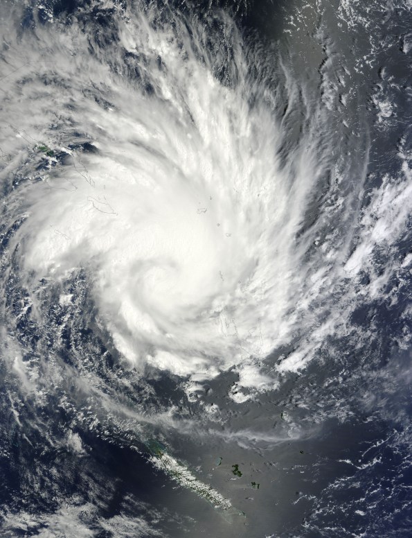
NASA's Terra satellite captured an image of Yasi on Jan. 30 at 23:20 UTC (6:20 p.m. EST/09:20 a.m., Monday, January 31 in Australia/Brisbane local time). Although the image did not reveal a visible eye, the storm appears to be well-formed and also appears to be strengthening. Credit: NASA Goddard / MODIS Rapid Response Team
Tropical Storm Anthony made landfall in Queensland, Australia this past weekend, and now the residents are watching a larger, more powerful cyclone headed their way. NASA’s Terra satellite captured a visible image of the large Tropical Cyclone Yasi late yesterday as it makes its way west through the Coral Sea toward Queensland.
The Moderate Resolution Imaging Spectroradiometer (MODIS) instrument that flies aboard NASA’s Terra satellite captured an image of Cyclone Yasi on Jan. 30 at 23:20 UTC (6:20 p.m. EST/09:20 a.m., Monday, January 31 in Australia/Brisbane local time). Although the image did not reveal a visible eye, the storm appears to be well-formed and also appears to be strengthening.
Warnings and watches are already in effect throughout the Coral Sea. The Solomon Islands currently have a Tropical Cyclone warning for Read more…
Storms hit Western Australia southwest as cyclone nears
 Saturday afternoon’s storms caused damage in parts of Perth and regional towns to the east, including Toodyay, Northam, York and Wongan Hills.
State Emergency Service volunteers have responded to 20 calls for assistance in Perth for rain damage, localised flooding and roof collapses, the Fire and Emergency Services Authority (FESA) said.
In Northam and York, east of Perth, around 30 buildings were badly damaged, many with roofs torn off, and powerlines and other structures were also hammered, it said.
Between Northampton and Jurien Bay, north of Perth, there had been 18 calls for assistance for damaged roofs.
The stormy weather cut power to around 55,000 homes in WA’s south on Saturday as the category three cyclone Bianca approached across the Indian Ocean. Read more…
Australian ‘inland sea’ flood threatens towns
 MELBOURNE — Australia’s flood crisis deepened Saturday with a giant “inland sea” threatening more communities in the southeast, as officials continued the grim search for bodies in worst-hit Queensland.
Sandbagging was underway in some villages in Victoria, where weeks of floods have affected as much as one-third of the state, with swollen rivers overflowing in 75 towns and flooding some 1,770 properties.
“We know that this is the most significant flooding in the north west of Victoria since records began… about 130 years ago,” a spokeswoman for the State Emergency Service told AFP.
“We are still on alert for towns in the north of the state.”
Floodwaters which national broadcaster ABC described as a moving “inland sea” covering an area 90 kilometres (56 miles) long and 40 kilometres wide, were threatening towns around Swan Hill, some 300 kilometres northwest of Melbourne.
“In the actual Swan Hill township itself, we are very confident that the levee system around the town is built to a very high grade and will protect the township,” Mayor Greg Cruickshank told ABC radio.
But rural and outlying areas “will have significant amount of inundation through them,” he said.
While thousands of people around the state have been urged to evacuate, emergency services warned that those people who choose to remain on their properties in the rural areas could be stranded by the floods.
“A number of these communities will be isolated for days as this huge amount of floodwater comes through,” SES spokesman Kevin Monk said. Read more…
Huge ring appears over Australia, is HAARP involved?
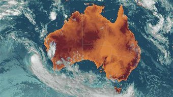
After receiving an urgent e-mail from a contact in Australia informing me of bizarre weather on the weather satellite imagery, I checked out the data and just hours later more strangeness. I am waiting to hear from the Australian Government’s weather bureau for their own explanation.
“There is very strange weather happening here – please check”
Written at 2230 Hrs (US Eastern) 15th January 2010.
A contact in Australia just alerted me to what he describes as “very strange weather taking place over the south west of Australia”. He told me to go to the national weather satellite images if I could not open the images he attached (See left). By the time I had discovered the e-mail and checked, the large clearly defined ring had mostly dissipated but still was just visible on a time loop which was spiraling counter clockwise (Low Pressure system). Read more…


![[Most Recent Quotes from www.kitco.com]](https://i0.wp.com/www.kitconet.com/charts/metals/gold/t24_au_en_usoz_2.gif)
![[Most Recent Quotes from www.kitco.com]](https://i0.wp.com/www.kitconet.com/charts/metals/silver/t24_ag_en_usoz_2.gif)

You must be logged in to post a comment.