Archive
Death toll from Madagascar cyclone rises to 16
ANTANANARIVO: At least 16 people were killed and 10,000 forced from their homes when Cyclone Giovanna pounded Madagascar, the disaster management bureau said Wednesday as it continued assessing the damage.
The storm struck in the early hours of Tuesday, lashing the towns of Tamatave and Brickaville on the east coast before drenching the capital Antananarivo about 220 kilometres (135 miles) inland.
By Wednesday morning, the storm had passed over the vast Indian Ocean island nation, leaving one person dead in the capital, eight in Brickaville and seven in Moramanga, 114 kilometres east of Antananarivo, according to officials.
The disaster management bureau said the death toll could still increase. Of the 592 communities hit by the storm, contact had been restored with just 80.
Officials said 65 people had been Full article here
Major storms set to increase
by Kate Taylor
So-called ‘storms of the century’ like last August’s Hurricane Irene could become almost commonplace, thanks to climate change.
 A team from MIT and Princeton University says that such storms could make landfall far more frequently, causing powerful, devastating storm surges every three to 20 years.
The group simulated tens of thousands of storms under different climate conditions, and concluded that the sort of severe floods which now hit every five hundred years or so could, with climate change, start happening once every 25 to 240 years.
MIT postdoc Ning Lin says that planners should take the findings into account when designing seawalls and other protective structures.
“When you design your buildings or dams or structures on the coast, you have to know how high your seawall has to be,” Lin says. “You have to decide whether to build a seawall to prevent being flooded every 20 years.”
To simulate present and future storm activity, using New York City as a case study, the researchers combined four Read more…
2010 – 2011: Earth’s most extreme weather since 1816?
 Every year extraordinary weather events rock the Earth. Records that have stood centuries are broken. Great floods, droughts, and storms affect millions of people, and truly exceptional weather events unprecedented in human history may occur. But the wild roller-coaster ride of incredible weather events during 2010, in my mind, makes that year the planet’s most extraordinary year for extreme weather since reliable global upper-air data began in the late 1940s. Never in my 30 years as a meteorologist have I witnessed a year like 2010–the astonishing number of weather disasters and unprecedented wild swings in Earth’s atmospheric circulation were like nothing I’ve seen. The pace of incredible extreme weather events in the U.S. over the past few months have kept me so busy that I’ve been unable to write-up a retrospective look at the weather events of 2010. But I’ve finally managed to finish, so fasten Read more…
Australia evaluates sea level threats

Fierce forecast: Feds predict up to 10 Atlantic hurricanes in 2011
Federal forecasters Thursday called for an “above-normal” hurricane season this year. They predict anywhere from 12-18 named storms to form in the Atlantic Ocean, Caribbean Sea and Gulf of Mexico.
Of those named storms, six to 10 should become hurricanes, including three to six “major” hurricanes, with wind speeds above 111 mph.
Tropical storms are given a name when wind speeds reach 39 mph. They are upgraded to hurricane status when their sustained winds reach 74 mph. An average Atlantic hurricane season sees 11 named storms, including six hurricanes; two become major hurricanes.
Forecasters do not predict the number of storms that will make landfall.
Climate factors in this outlook include unusually warm Atlantic Ocean water and temperatures two degrees above average, reports Gerry Bell, lead seasonal forecaster at the Climate Prediction Center. Additionally, the impacts of the La Nina climate pattern, such as reduced wind shear, are expected to continue into the hurricane season.
“In addition to multiple climate factors, seasonal climate models also indicate an above-normal season is likely, and even suggest we could see activity comparable to some of the active seasons since 1995,” Bell said.
Since 1995, Bell says the Atlantic is in an era of increased hurricane activity. There are consistently favorable ocean and atmospheric conditions for storm formation.
Thursday’s NOAA forecast is similar to earlier predictions by researchers at Colorado State University and the AccuWeather commercial weather service. The Colorado State team, led by Read more…
Disasters to slash Australian growth by 1 pct
 SYDNEY — The hit to exports from Japan’s quake and tsunami, devastating floods in its own northeast and a rallying dollar has shaved 1.0 percent off Australia’s growth forecasts, according to a report.
Accompanied by a slump in consumer spending, the disasters have led the Treasury to downgrade growth from the 3.25 percent flagged in November’s budget update to 2.25 percent, said The Age newspaper on Saturday, citing an internal memo.
The devastation and nuclear crisis in key trading partner Japan wiped 0.25 percent from economic growth, according to the memo, with Australia’s Read more…
EXTREME WEATHER AND EARTHQUAKE DANGER IMMINENT around 23rd-27th March warns Piers Corbyn
The very active solar region which emerged from the SE limb of the sun on the morning of 21st March is crackling with dangerous activity including extreme UV radiation and up to 50Mev proton bursts and its appearance along with other active regions on the sun fits our WeatherAction.com long-range WARNING for significant weather extremes and earthquakes in the period around 23rd-27th March, issued during February.
WATCH SOLAR ACTION DEVELOP…
Solar activity details: http://spaceweather.com/archive.php?month=03&day=21&year=2011&view=view ( = http://bit.ly/h13CuA use forward button to get to next day) and http://www.lmsal.com/solarsoft/latest_events/ 2nd graph down purple blip is 50Mev. The other levels are different colours. Notice 1Mev is staying high on 22nd also. Note the Spaceweather link already shows a solar wind stream from a coronal hole will hit Earth 23/24th March, the newly reported activity on the sun will lead to earth hits following that. Solar wind hit 527km/sec – that’s fast on 23rd March. Geomagnetic Activity – should increase in 23-27th periods – See http://www.swpc.noaa.gov/rt_plots/kp_3d.html
We warned of these dangers – with weather event detail for USA, West Europe, Australia, New Zealand Read more…
Queensland counts Yasi’s huge cost
By Greg Ansley
 Under leaden skies and sheets of torrential rain that obscured its ranges, north Queensland was last night counting both costs and blessings as Cyclone Yasi raged far into the west, losing potency as it went.
The massive category-five cyclone – raging on to the coast between Cairns and Townsville early yesterday and cutting a 1000km-wide swathe – was the largest storm in the state’s modern history.
But while it caused huge damage, it missed the region’s biggest population centres and, as far as authorities could judge last night, left no one dead or seriously injured. However, last night, two men were missing in Innisfail.
In Cairns, three babies were born at Yasi’s peak – one a girl in an evacuation centre, helped by a midwife also sheltering there.
There may yet be some tragic shocks: Read more…
Tropical Cyclone Yasi Headed Toward Queensland, Australia

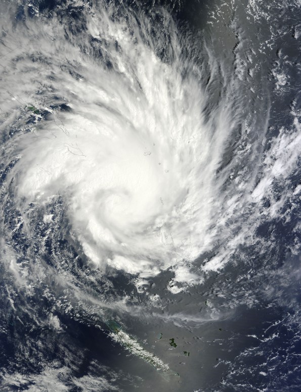
NASA's Terra satellite captured an image of Yasi on Jan. 30 at 23:20 UTC (6:20 p.m. EST/09:20 a.m., Monday, January 31 in Australia/Brisbane local time). Although the image did not reveal a visible eye, the storm appears to be well-formed and also appears to be strengthening. Credit: NASA Goddard / MODIS Rapid Response Team
Tropical Storm Anthony made landfall in Queensland, Australia this past weekend, and now the residents are watching a larger, more powerful cyclone headed their way. NASA’s Terra satellite captured a visible image of the large Tropical Cyclone Yasi late yesterday as it makes its way west through the Coral Sea toward Queensland.
The Moderate Resolution Imaging Spectroradiometer (MODIS) instrument that flies aboard NASA’s Terra satellite captured an image of Cyclone Yasi on Jan. 30 at 23:20 UTC (6:20 p.m. EST/09:20 a.m., Monday, January 31 in Australia/Brisbane local time). Although the image did not reveal a visible eye, the storm appears to be well-formed and also appears to be strengthening.
Warnings and watches are already in effect throughout the Coral Sea. The Solomon Islands currently have a Tropical Cyclone warning for Read more…
Storms hit Western Australia southwest as cyclone nears
 Saturday afternoon’s storms caused damage in parts of Perth and regional towns to the east, including Toodyay, Northam, York and Wongan Hills.
State Emergency Service volunteers have responded to 20 calls for assistance in Perth for rain damage, localised flooding and roof collapses, the Fire and Emergency Services Authority (FESA) said.
In Northam and York, east of Perth, around 30 buildings were badly damaged, many with roofs torn off, and powerlines and other structures were also hammered, it said.
Between Northampton and Jurien Bay, north of Perth, there had been 18 calls for assistance for damaged roofs.
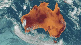
The stormy weather cut power to around 55,000 homes in WA’s south on Saturday as the category three cyclone Bianca approached across the Indian Ocean. Read more…


![[Most Recent Quotes from www.kitco.com]](https://i0.wp.com/www.kitconet.com/charts/metals/gold/t24_au_en_usoz_2.gif)
![[Most Recent Quotes from www.kitco.com]](https://i0.wp.com/www.kitconet.com/charts/metals/silver/t24_ag_en_usoz_2.gif)

You must be logged in to post a comment.