Archive
Australian state of Queensland stages its biggest ever evacuation as floodwaters rise

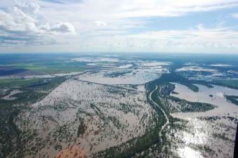
An aeriel view of the swollen Balonne River in Queensland is seen just before water levels peaked at 12.75 metres (42 feet) on Jan. 4, 2011. The river is now threatening to reach new highs, devastating the township of St George. AFP/Getty Images
MELBOURNE (Australia) – Thousands of people have been evacuated from the parts of the eastern Australian state of Queensland, where river heights are threatening to reach record levels, local media report.
Over 2,000 people were forcibly evacuated from the inland township of St George on Saturday night, in what the Australian Broadcasting Corporation says was the largest evacuation in the state’s history.
The Australian newspaper says the nearby Balonne River has already passed the all-time high of 13.4 metres (44 feet) recorded during the devastating floods of 2010, and it is expected to continue rising to over 14 metres (46 feet).
The newspaper says that some 300 to 400 residents had stayed to protect their properties, ignoring warnings that rescue services might not be able to reach them later. Some had built a temporary levee in an attempt to hold back some of the water, but the state Premier Anna Bligh said their efforts had “no prospect” of succeeding. Twenty houses were destroyed over the weekend and a final evacuation was scheduled for Monday morning, local time.
“This is the third flood this town has coped with in just less than two years, so there’s a lot of distress and a lot of emotion,” Bligh added, confirming that she would visit the flood-affected areas on Monday.
Later on Monday morning, some media began reporting that Read more…
EXTREME WEATHER AND EARTHQUAKE DANGER IMMINENT around 23rd-27th March warns Piers Corbyn
The very active solar region which emerged from the SE limb of the sun on the morning of 21st March is crackling with dangerous activity including extreme UV radiation and up to 50Mev proton bursts and its appearance along with other active regions on the sun fits our WeatherAction.com long-range WARNING for significant weather extremes and earthquakes in the period around 23rd-27th March, issued during February.
WATCH SOLAR ACTION DEVELOP…
Solar activity details: http://spaceweather.com/archive.php?month=03&day=21&year=2011&view=view ( = http://bit.ly/h13CuA use forward button to get to next day) and http://www.lmsal.com/solarsoft/latest_events/ 2nd graph down purple blip is 50Mev. The other levels are different colours. Notice 1Mev is staying high on 22nd also. Note the Spaceweather link already shows a solar wind stream from a coronal hole will hit Earth 23/24th March, the newly reported activity on the sun will lead to earth hits following that. Solar wind hit 527km/sec – that’s fast on 23rd March. Geomagnetic Activity – should increase in 23-27th periods – See http://www.swpc.noaa.gov/rt_plots/kp_3d.html
We warned of these dangers – with weather event detail for USA, West Europe, Australia, New Zealand Read more…
Moon at Maximum Traction During Latest Earthquake Clusters
The moon’s gravitational impact on the earth, especially between February and April this year, coincides with the latest cluster of major earthquakes.
 (13th March 2011) Many astronomers and climate scientists studying the relationship of the moon with the orbits of the earth and sun, have noted that lunar perigree can coincide with major tectonic activity.
Lunar perigree is when the moon’s orbit is closest to the earth, as on 19th March 2011, but a proxigean cycle is even stronger.
This occurs when the moon is closest in orbit to the Earth, (this year between March 18th and 21st), and also in its new or full Moon phase.
Present proxigean cycle has maximum effect
This proxigean cycle is when the moon Read more…
Giant rats lead scientists to ancient face carvings
Credit: John Brush
The team of archaeologists and palaeontologists were working in Lene Hara Cave on the northeast tip of East Timor.
“Looking up from the cave floor at a colleague sitting on a ledge, my head torch shone on what seemed to be a weathered carving,” CSIRO’s Dr Ken Aplin said.
“I shone the torch around and saw a whole panel of engraved prehistoric human faces on the wall of the cave. Read more…
Russian volcano activity causes global concern
Now the world has something else to grip about when it comes to Russia – the weather.
A string of volcanoes on Russia’s eastern seaboard of Kamchatka have been unusually active for the last six months. The dust they threw up diverted winds in the Arctic, pushing cold air over Europe and North America and causing the unusually cold winter this year, say scientists.
The volcanoes (160 in total, of which 29 are active) are still on the go and could create more problems this year, depressing harvests around the world just as global food prices soar and Read more…
Climate phenomenon La Nina to blame for global extreme weather events

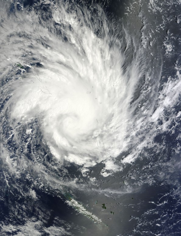
Cyclone Yasi over Australia in February 2011. Image credit: NASA
(PhysOrg.com) — Recent extreme weather events as far as Australia and Africa are being fueled by a climate phenomenon known as La Nina — or “the girl” in Spanish. La Nina has also played a minor role in the recent cold weather in the Northeast U.S.
The term La Niña refers to a period of cooler-than-average sea-surface temperatures in the Equatorial Pacific Ocean that occurs as part of natural climate variability. This situation is roughly the opposite of what happens during El Niño (“the boy”) events, when surface waters in this region are warmer than normal. Because the Pacific is the largest ocean on the planet, any significant changes in average conditions there can have consequences for temperature, rainfall and vegetation in distant places.
Scientists at the International Research Institute for Climate and Society (IRI), part of Columbia’s Earth Institute, expect moderate-to-strong La Niña conditions to continue in the tropical Pacific, potentially causing additional shifts in rainfall patterns across Read more…
Map shows most of Northern Hemisphere is covered in snow and ice
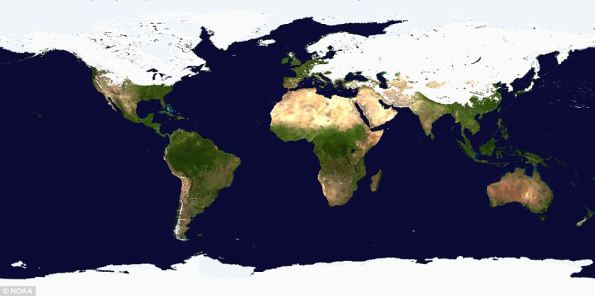
At first glance it looks like a graphic from a Discovery Channel program about a distant ice age. But this astonishing picture shows the world as it is today – with half the Northern Hemisphere covered with snow and ice.
The image was released by the National Oceanic And Atmospheric Association (NOAA) on the day half of North America was in the grip of a severe winter storm.
The map was created using multiple satellites from government agencies and the US Air Force.
That Antarctica, the Arctic, Greenland and the frozen wastes of Siberia are covered in white comes as no surprise. But it is the extent to which the line dips down over the Northern Hemisphere that is so remarkable about the image.
The shroud of white stretches down from Alaska and sweeps through the Midwest and along to the Eastern seaboard. The bitter cold has reached as far as Texas and northern Mexico where in Ciudad Juarez temperatures today were expected to dip to minus 15C.
In the U.S. tens of millions of people chose to stay at home rather than venture out. In Chicago, 20in of snow fell leading to authorities closing schools for the first time in 12 years. The newspaper for Tulsa, Okalahoma, was unable to publish its print edition for the first time in Read more…
Queensland counts Yasi’s huge cost
By Greg Ansley
 Under leaden skies and sheets of torrential rain that obscured its ranges, north Queensland was last night counting both costs and blessings as Cyclone Yasi raged far into the west, losing potency as it went.
The massive category-five cyclone – raging on to the coast between Cairns and Townsville early yesterday and cutting a 1000km-wide swathe – was the largest storm in the state’s modern history.
But while it caused huge damage, it missed the region’s biggest population centres and, as far as authorities could judge last night, left no one dead or seriously injured. However, last night, two men were missing in Innisfail.
In Cairns, three babies were born at Yasi’s peak – one a girl in an evacuation centre, helped by a midwife also sheltering there.
There may yet be some tragic shocks: Read more…
Tropical Cyclone Yasi Headed Toward Queensland, Australia

NASA's Terra satellite captured an image of Yasi on Jan. 30 at 23:20 UTC (6:20 p.m. EST/09:20 a.m., Monday, January 31 in Australia/Brisbane local time). Although the image did not reveal a visible eye, the storm appears to be well-formed and also appears to be strengthening. Credit: NASA Goddard / MODIS Rapid Response Team
Tropical Storm Anthony made landfall in Queensland, Australia this past weekend, and now the residents are watching a larger, more powerful cyclone headed their way. NASA’s Terra satellite captured a visible image of the large Tropical Cyclone Yasi late yesterday as it makes its way west through the Coral Sea toward Queensland.
The Moderate Resolution Imaging Spectroradiometer (MODIS) instrument that flies aboard NASA’s Terra satellite captured an image of Cyclone Yasi on Jan. 30 at 23:20 UTC (6:20 p.m. EST/09:20 a.m., Monday, January 31 in Australia/Brisbane local time). Although the image did not reveal a visible eye, the storm appears to be well-formed and also appears to be strengthening.
Warnings and watches are already in effect throughout the Coral Sea. The Solomon Islands currently have a Tropical Cyclone warning for Read more…


![[Most Recent Quotes from www.kitco.com]](https://i0.wp.com/www.kitconet.com/charts/metals/gold/t24_au_en_usoz_2.gif)
![[Most Recent Quotes from www.kitco.com]](https://i0.wp.com/www.kitconet.com/charts/metals/silver/t24_ag_en_usoz_2.gif)

You must be logged in to post a comment.