Archive
Super Typhoon Songda Projected To Pass Over Fukushima Nuclear Power Plant
So far the only good news to accompany the Fukushima catastrophe has been that for all the fallout, the radiation has been mostly contained due to Northwesterly winds which have been blowing any radioactivity mostly out and into the Pacific (coupled with relatively little rainfall), as well as the dispersion of irradiated cooling water which promptly enters the Pacific after which it is never heard of or seen again (there is at least a several year period before 3 eyed tuna fish feature prominently in restaurants across the country). This may be changing soon now that Super Typhoon Songda, which according to Weather Underground will form shortly as a Category 5 storm with 156+ mph winds, will take a northeasterly direction and 2 days later will pass right above Fukushima. The good news: by the time it passes over Fukushima, Songda will be merely a Tropical storm. The bad news: by the time it passes over Fukushima, Songda will be a Tropical storm. As the latest dispersion projection from ZAMG shows, over the next two days the I-131 plume will be covering all of the mainland. Although judging by how prominent this whole topic is in the MSM lately, it seems that conventional wisdom now agrees with Ann Coulter that radioactivity is actually quite good for you.
From wunderground.com:
And the latest plume projection: Read more…
Fierce forecast: Feds predict up to 10 Atlantic hurricanes in 2011
Federal forecasters Thursday called for an “above-normal” hurricane season this year. They predict anywhere from 12-18 named storms to form in the Atlantic Ocean, Caribbean Sea and Gulf of Mexico.
Of those named storms, six to 10 should become hurricanes, including three to six “major” hurricanes, with wind speeds above 111 mph.
Tropical storms are given a name when wind speeds reach 39 mph. They are upgraded to hurricane status when their sustained winds reach 74 mph. An average Atlantic hurricane season sees 11 named storms, including six hurricanes; two become major hurricanes.
Forecasters do not predict the number of storms that will make landfall.
Climate factors in this outlook include unusually warm Atlantic Ocean water and temperatures two degrees above average, reports Gerry Bell, lead seasonal forecaster at the Climate Prediction Center. Additionally, the impacts of the La Nina climate pattern, such as reduced wind shear, are expected to continue into the hurricane season.
“In addition to multiple climate factors, seasonal climate models also indicate an above-normal season is likely, and even suggest we could see activity comparable to some of the active seasons since 1995,” Bell said.
Since 1995, Bell says the Atlantic is in an era of increased hurricane activity. There are consistently favorable ocean and atmospheric conditions for storm formation.
Thursday’s NOAA forecast is similar to earlier predictions by researchers at Colorado State University and the AccuWeather commercial weather service. The Colorado State team, led by Read more…
Texas Wildfires Threaten Wheat Crop, Drive Food Prices Higher

As firefighters from around the country and the National Guard continue to battle the many blazes scattered across the state, with no immediate end to the crisis in sight, the future looks bleak for Texas farmers. Many farmers’ fields were already damaged by drought, and now some crops have been further harmed by smoke or entirely destroyed by flame.
Some agricultural experts are now predicting that Texas will lose two thirds of this year’s wheat crop to drought and Read more…
Tropical Cyclone Yasi Headed Toward Queensland, Australia

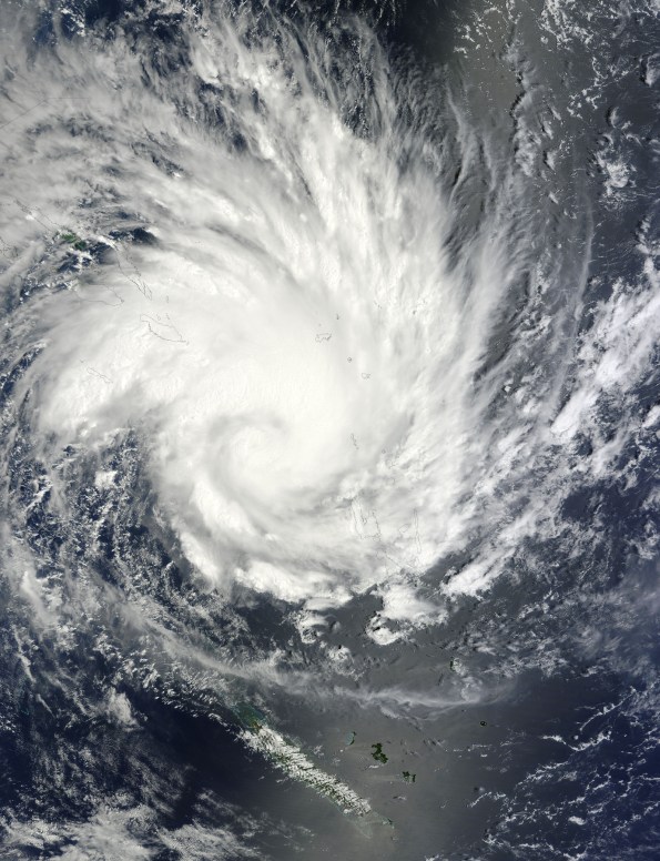
NASA's Terra satellite captured an image of Yasi on Jan. 30 at 23:20 UTC (6:20 p.m. EST/09:20 a.m., Monday, January 31 in Australia/Brisbane local time). Although the image did not reveal a visible eye, the storm appears to be well-formed and also appears to be strengthening. Credit: NASA Goddard / MODIS Rapid Response Team
Tropical Storm Anthony made landfall in Queensland, Australia this past weekend, and now the residents are watching a larger, more powerful cyclone headed their way. NASA’s Terra satellite captured a visible image of the large Tropical Cyclone Yasi late yesterday as it makes its way west through the Coral Sea toward Queensland.
The Moderate Resolution Imaging Spectroradiometer (MODIS) instrument that flies aboard NASA’s Terra satellite captured an image of Cyclone Yasi on Jan. 30 at 23:20 UTC (6:20 p.m. EST/09:20 a.m., Monday, January 31 in Australia/Brisbane local time). Although the image did not reveal a visible eye, the storm appears to be well-formed and also appears to be strengthening.
Warnings and watches are already in effect throughout the Coral Sea. The Solomon Islands currently have a Tropical Cyclone warning for Read more…
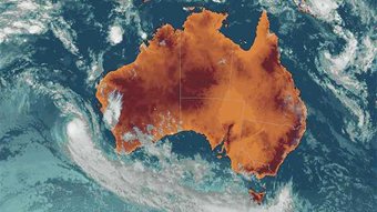
Storms hit Western Australia southwest as cyclone nears
 Saturday afternoon’s storms caused damage in parts of Perth and regional towns to the east, including Toodyay, Northam, York and Wongan Hills.
State Emergency Service volunteers have responded to 20 calls for assistance in Perth for rain damage, localised flooding and roof collapses, the Fire and Emergency Services Authority (FESA) said.
In Northam and York, east of Perth, around 30 buildings were badly damaged, many with roofs torn off, and powerlines and other structures were also hammered, it said.
Between Northampton and Jurien Bay, north of Perth, there had been 18 calls for assistance for damaged roofs.
The stormy weather cut power to around 55,000 homes in WA’s south on Saturday as the category three cyclone Bianca approached across the Indian Ocean. Read more…


![[Most Recent Quotes from www.kitco.com]](https://i0.wp.com/www.kitconet.com/charts/metals/gold/t24_au_en_usoz_2.gif)
![[Most Recent Quotes from www.kitco.com]](https://i0.wp.com/www.kitconet.com/charts/metals/silver/t24_ag_en_usoz_2.gif)

You must be logged in to post a comment.