Archive
RUSSIA WARNS: ASTEROID IMPACT in Atlantic Ocean
Russian Military Operatives who have family in the United States have warned of an upcoming event of a large Asteroid that is being tracked by their missle defense systems. This Near Earth Object is arriving along with the Meteor Debris field expected to impact FEMA Region Three. Russia Warns that this Large Asteroid will Impact in the Atlantic Ocean. This will be a Global Incident. This event will change life on this planet as we know it. Good Luck to you and your Family.
Scientist: East Coast Cities are ‘Sitting Ducks’ for Storms
Cities on the United States east coast are “sitting ducks” for the next big storm because of the destruction wrought by Hurricane Sandy, one of Barack Obama’s top scientists warned on Tuesday.
 Marcia McNutt, who last week announced her resignation as director of the U.S. Geological Survey, told a conference that Sandy had left coastal communities dangerously exposed to future storms of any size.
Hurricane Sandy churns off the U.S. east coast in the Atlantic Ocean.
Credit: NASA/Getty Images
“Superstorm Sandy was a threshold for the north-east and we have already crossed it,” McNutt told the National Council for Science and the Environment conference in Washington. “For the next storm, not even a super storm, even a run-of-the-mill nor’easter, the amount of breaches and the amount of coastal Read more…
Nigerian flooding claims 102 lives: Red Cross
LAGOS — At least 102 people were killed when a dam burst in torrential rain and flooding in southwest Nigeria, a local Red Cross official told AFP Wednesday.
“The death toll for now… is 102,” said Umar Mairiga, disaster management coordinator for the Nigerian Red Cross Society.
He said the Eleyele dam collapsed and several bridges were swept away at the weekend after heavy rains fell for more than seven Read more…
Tropical storm Katia forms in Atlantic
 The name Katia replaces Katrina, which was retired from the rotating roster of storm names after the devastating 2005 storm that devastated New Orleans. ((U.S. National Hurricane Center)
Tropical storm Katia has formed in the Atlantic and could reach hurricane intensity by late Wednesday or early Thursday, the U.S. National Hurricane Center says.
By late Tuesday afternoon, Katia was located about 1,207 kilometres west of the southernmost Cape Verde Islands and moving “quickly west-northwestward across the tropical Atlantic,” the Miami-based centre said Tuesday.
The storm’s maximum sustained winds had increased to 97 km/h by Tuesday afternoon, and additional strengthening is forecast over the next 48 hours. Katia could become a hurricane by Wednesday, the hurricane centre said.
Hurricane specialist Michael Brennan said Tuesday morning that Katia could affect Read more…
New underwater volcanic vents discovered along the Mid-Atlantic Ridge
theextinctionprotocol.wordpress.com

August 16, 2011 – MID-ATLANTIC RIDGE – The Irish-led VENTuRE scientific expedition aboard the national research vessel RV Celtic Explorer has discovered a previously uncharted field of hydrothermal vents along the mid-Atlantic ridge – the first to be explored north of the Azores. The mission, led by Dr. Andy Wheeler of University College, Cork (UCC), together with scientists from the National Oceanographic Centre and the University of Southampton in the UK, NUI Galway and the Geological Survey of Ireland, returned to Cork today (August 4th) from an investigation 3,000 metres below the surface of the sea using the Remotely Operated Vehicle (ROV) Holland 1. Hydrothermal vents, which spew mineral-rich seawater heated to boiling point by volcanic rock in the Earth’s crust below, are home to
Never Mind Bret, Season is Just Getting Started
 The circle gets the square, or in this case, the big red circle near Africa has room to become the strongest feature yet for the 2011 season.
“A stronger tropical wave now over the eastern North Atlantic might be a feature to watch during the next week or so.”While Bret is now pushing out to sea and remains no threat to the mainland U.S., indications continue to point toward a busy August and September as far as hurricanes are concerned.
A sizable tropical wave has rolled westward, off the coast of Africa, and bears watching as it cruises along through Antilles waters this weekend.
It is still a little early to expect much from the Cape Verde area, but one of the tropical waves could help to breed a tropical cyclone in the southwestern part of the Atlantic Basin by next week.
According to Tropical Weather and Hurricane Expert Meteorologist Dan Kottlowski, “A stronger tropical wave now over the Read more…
Rising Oceans – Too Late to Turn the Tide?
(Click to enlarge) If sea levels rose to where they were during the Last Interglacial Period, large parts of the Gulf of Mexico would be under water (red areas), including half of Florida and several Caribbean islands. (Photo illustration by Jeremy Weiss)
Melting ice sheets contributed much more to rising sea levels than thermal expansion of warming ocean waters during the Last Interglacial Period, a UA-led team of researchers has found. The results further suggest that ocean levels continue to rise long after warming of the atmosphere has leveled off.
Thermal expansion of seawater contributed only slightly to rising sea levels compared to melting ice sheets during the Last Interglacial Period, a University of Arizona-led team of researchers has found.
The study combined paleoclimate records with computer simulations of Read more…
Underwater Antarctic Volcano Chain Discovered In The Southern Ocean
 Scientists from British Antarctic Survey (BAS) have discovered previously unknown volcanoes in the ocean waters around the remote South Sandwich Islands. Using ship-borne sea-floor mapping technology during research cruises onboard the RRS James Clark Ross, the scientists found 12 volcanoes beneath the sea surface – some up to 3km high. They found 5km diameter craters left by collapsing volcanoes and 7 active volcanoes visible above the sea as a chain of islands.Sea-floor mapping technology reveals volcanoes beneath the sea surface Read more…
A Lost World? Atlantis-Like Landscape Discovered
 |
| This image of the ancient buried landscape discovered deep beneath the sediment of the North Atlantic Ocean was made using sound waves bounced off different rock layers. An ancient meandering riverbed is visible. CREDIT: R A Hartley et al. |
Buried deep beneath the sediment of the North Atlantic Ocean lies an ancient, lost landscape with furrows cut by rivers and peaks that once belonged to mountains. Geologists recently discovered this roughly 56-million-year-old landscape using data gathered for oil companies.
“It looks for all the world like a map of a bit of a country onshore,” said Nicky White, the senior researcher. “It is like an ancient fossil landscape preserved 2 kilometers (1.2 miles) beneath the seabed.”
So far, the data have revealed a landscape about 3,861 square miles (10,000 square km) west of the Orkney-Shetland Islands that stretched Read more…
Is the Massive Puerto Rico Trench Awakening?
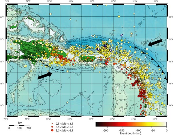
by Zen Gardner
“What Puerto Rico Trench?” Exactly.
The arrows in the map above show the direction the underlying Caribbean tectonic plates are moving, with the resultant build-up of pressure releasing into a myrid of earthquakes in the region over the years. Puerto Rico is the smaller green island in the middle, with the Dominican Republic the larger island to the left. The string of other Caribbean islands is buried under the earthquake markers that Read more…

![[Most Recent Quotes from www.kitco.com]](https://i0.wp.com/www.kitconet.com/charts/metals/gold/t24_au_en_usoz_2.gif)
![[Most Recent Quotes from www.kitco.com]](https://i0.wp.com/www.kitconet.com/charts/metals/silver/t24_ag_en_usoz_2.gif)


You must be logged in to post a comment.