Archive
Unusual Fault Pattern Surfaces in Earthquake Study
 This 3-D view of the surface rupture of the April 4, 2010, El Mayor-Cucapah earthquake (red line) reveals a new fault line connecting the Gulf of California with the Elsinore fault, which could become a major part of the boundary between the Pacific and the North America Plates. Image credit: Caltech Tectonics Observatory |
Like scars that remain on the skin long after a wound has healed, earthquake fault lines can be traced on Earth’s surface long after their initial rupture. Typically, this line of intersection between the area where the fault slips and the ground is more complicated at the surface than at depth.
But a new study of the April 4, 2010, El Mayor-Cucapah earthquake in Mexico reveals a reversal of this trend. While the fault involved in the event appeared to be superficially straight, the fault zone is warped and complicated at depth.
The study-led by researchers at the California Institute of Technology (Caltech) and documenting findings from the magnitude 7.2 event, which was centered in the Baja California state of Mexico-is available online in the journal Nature Geoscience.
The El Mayor-Cucapah earthquake happened along a system of Read more…
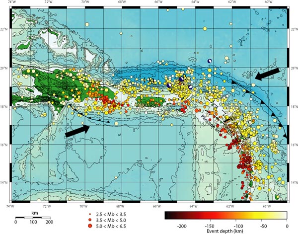
Is the Massive Puerto Rico Trench Awakening?
by Zen Gardner
“What Puerto Rico Trench?” Exactly.
The arrows in the map above show the direction the underlying Caribbean tectonic plates are moving, with the resultant build-up of pressure releasing into a myrid of earthquakes in the region over the years. Puerto Rico is the smaller green island in the middle, with the Dominican Republic the larger island to the left. The string of other Caribbean islands is buried under the earthquake markers that Read more…
Case Study: Tsunami in Seaside, Oregon
Oregon Coast’s Vulnerability
 Recent research suggests that a Cascadia Subduction Zone earthquake could create tsunami waves that impact over 1,000-km of coastline in the U.S. and Canada. Source: USGS
The northwestern coast of Oregon is susceptible to both local and far-field tsunamis. The Cascadia Subduction Zone, where the eastward moving Juan de Fuca plate meets the westward moving North American Plate, is just off the Pacific Northwest coast of the United States and Canada. It is a 750-kilometer long fault zone. This area is very active tectonically, and therefore has the potential to produce large earthquakes and possibly, subsequent tsunamis. This subduction zone is thought to have last ruptured in 1700.
Additionally, far-field earthquakes throughout the Pacific are also capable of spawning tsunamis that could eventually reach the Oregon coast. Historical records show that since 1812, about 28 tsunamis with wave heights greater than one meter have reached the U.S. west coast. The March 1964 “Good Friday” earthquake created the most devastating of these tsunamis. The epicenter of this earthquake was near Anchorage, Alaska. The tsunami that followed this earthquake reached coasts all along the western U.S. within six hours. Cannon Beach, a small coastal community in northwestern Oregon was inundated during Read more…
Drifting apart: Amazing underwater photos that show the growing gap between two tectonic plates
Swimming through an area of extreme natural beauty, this diver surveys the underwater canyons on his either side.
But this British scuba diver is actually between two tectonic plates.
Alex Mustard, 36, dived 80ft into the crevice between the North American and Eurasian plates near Iceland to capture these spectacular photos.

Geologists warn another earthquake could tear Tokyo in two after weakening of fault line below capital
Geologists have warned that another powerful earthquake could inflict terrible damage on Tokyo because the Size 9 monster which struck on March 11 has altered the earth’s surface.
The quake has put pressure on the fault lines near the Japanese capital and experts have suggested that a size 7.5 magnitude earthquake could hit.
The structure of the tectonic plates and fault lines around the city makes it unlikely that Tokyo, home to 13million people, would be hit by a quake anywhere near the intensity of the one 10 days ago, said Roger Musson of the British Geological Survey.
 Bustling: The busy Japanese capital Tokyo has 13million people living in its centre – and it could be Read more…
4.3-magnitude earthquake near Mount St. Helens is biggest in 30 years
By Stuart Tomlinson, The Oregonian

Fault line, won’t you be my Valentine?
The second largest earthquake since Mount St. Helens erupted — a magnitude 4.3 shaker — rocked a fault line six miles north of the volcano Monday morning. People felt it as far away as Astoria, Lake Oswego, Hood River and even Bremerton, Wash., near Seattle.
The last one, as it happens, was 30 years ago also on Valentine’s Day, a magnitude 5.5 temblor.
That 1981 earthquake appeared to be the result of the earth’s crust readjusting after magma oozed up through the fault and blew the mountain’s Read more…
Seismic fault beneath us is ‘fully loaded’ after 311 years
Julie Muhlstein, Herald Columnist

As if you didn’t have enough worries, here is one more to add to that massive list:
“It’s been 300 years,” Bill Steele said Tuesday. “We have a fully loaded subduction zone.”
Actually, it’s been 311 years since the .
Steele, a University of Washington seismologist and spokesman for the Pacific Northwest Seismic Network, said scientists have determined the monster quake occurred Jan. 26, 1700 — 311 years ago tonight.
It happened off the Northwest coast, and created huge tsunamis that devastated shorelines here and in Japan.
What’s amazing is how much is known, considering that in 1700 there were no Europeans in the Northwest. British Capt. George Vancouver wouldn’t find his way here until 1792. The Lewis and Clark Expedition to the West didn’t start until 1804. Historians have no original account of the 1700 quake written from a Western perspective.
“There’s quite a detective story of how we know all that. It’s fantastic,” Steele said.
First, a quick explanation of what happened from the online encyclopedia HistoryLink: Read more…

![[Most Recent Quotes from www.kitco.com]](https://i0.wp.com/www.kitconet.com/charts/metals/gold/t24_au_en_usoz_2.gif)
![[Most Recent Quotes from www.kitco.com]](https://i0.wp.com/www.kitconet.com/charts/metals/silver/t24_ag_en_usoz_2.gif)


You must be logged in to post a comment.