Archive
Super typhoon Haiyan just broke all scientific intensity scales

Writing for Quartz, meteorologist Eric Holthaus says that the super typhoon Haiyan about to hit the Philippines is the worst storm he has ever seen. With sustained winds of 190mph (305km/h) and staggering gusts of 230mph (370km/h), its “intensity has actually ticked slightly above the maximum to 8.1 on an 8.0 scale.” Updated: It broke 235mph. Videos of the impact added.
Holthaus says that Yolanda—its Filipino name—beats “Wilma (2005) in intensity by 5mph—that was the strongest storm ever in the Atlantic,” which makes it a member of the select club of Worst Storms Ever in the Planet. Only three other storms since 1969 have reached this intensity.
That’s certainly foreboding enough, but the humanitarian disaster that may Read more…
Scientist: East Coast Cities are ‘Sitting Ducks’ for Storms
Cities on the United States east coast are “sitting ducks” for the next big storm because of the destruction wrought by Hurricane Sandy, one of Barack Obama’s top scientists warned on Tuesday.
 Marcia McNutt, who last week announced her resignation as director of the U.S. Geological Survey, told a conference that Sandy had left coastal communities dangerously exposed to future storms of any size.
Hurricane Sandy churns off the U.S. east coast in the Atlantic Ocean.
Credit: NASA/Getty Images
“Superstorm Sandy was a threshold for the north-east and we have already crossed it,” McNutt told the National Council for Science and the Environment conference in Washington. “For the next storm, not even a super storm, even a run-of-the-mill nor’easter, the amount of breaches and the amount of coastal Read more…
Researcher to speak on increased likelihood of Texas hurricanes

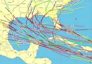
Galveston, Texas in the Gulf of Mexico has the highest rate of hurricane activity than anywhere else in the USA. The Gulf area reports more hurricane activity than any other part of the US.
The chances that a 15-inch rainfall might hit Central Texas in any given year have long been about 1-in-1,000. But with the warming of air that scientists expect over the century, some predict those chances might jump to 1-in-50.Kerry Emanuel, a prominent Massachusetts Institute of Technology meteorology professor, will lecture on the topic in Austin on Tuesday. The talk, titled “Hurricanes in the Gulf of Mexico: The History and Future of the Texas Coast,” is free and open to the public, part of the University of Texas’ Hot Science-Cool Talks series.
“We expect hurricane-related rainfall is going to get worse over next 100 years,” Emanuel said in an interview.
While that news might seem welcome in drought-stricken Central Texas — especially since moister, hurricane rain-saturated soils are likely to Read more…
Physics professor: Past decade ‘hottest ten years ever recorded’

On CBS This Morning on Thursday, Kaku discussed 2012′s “wacky weather” and how global warming, which creates more energy circulating on the planet, exacerbates destructive tornadoes, storms, hurricanes and even forest fires.
“You look at the weather patterns over the last year, and they all seem wild, extreme. What was driving that?” asked anchor Rebecca Jarvis.
“Well, when you look outside you say, ‘The weather’s on steroids,’” Kaku said. “But there’s no single aha moment where you can say, ‘Aha, this is what’s driving the whole thing.’ But what you can say is that the Earth is heating up. Which means more moisture going into Read more…
Climate change causing increase in extreme weather in South Pacific
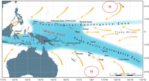
An international study led by CSIRO oceanographer Dr Wenju Cai has identified that global warming is causing shifts in the rain band of the South Pacific Convergence Zone causing an increase in extreme weather across the island nation states of the South Pacific. The result of the movement causes drought and higher prevalence of forest fire in some areas while other islands experience extreme floods and increased frequency of tropical cyclones.
The South Pacific Convergence Zone is the important rainband that stretches from the equatorial western Pacific southeastward toward French Polynesia. When the rainband moves northward, extreme climate events are induced. “Here we show that greenhouse warming Read more…
Atlantic Hurricane Forecast: Storms Close to the Coast
 Astronaut, Ron Garan, snapped this photo of Hurricane Irene from aboard the International Space Station on August 22, 2011. NOAA averages are based on data from 1981-2010.
AccuWeather’s 2012 Atlantic Hurricane Season forecasts 12 named tropical storms, five named hurricanes and two major hurricanes.
The 2012 hurricane forecast is near-normal for the Atlantic Basin.
Potential Impact This Year
Predicting exactly where storms will make landfall in the U.S. would be extremely difficult, but there are some indications of areas where storms may brew and coasts that may be vulnerable based on Read more…
Major storms set to increase
by Kate Taylor
So-called ‘storms of the century’ like last August’s Hurricane Irene could become almost commonplace, thanks to climate change.
 A team from MIT and Princeton University says that such storms could make landfall far more frequently, causing powerful, devastating storm surges every three to 20 years.
The group simulated tens of thousands of storms under different climate conditions, and concluded that the sort of severe floods which now hit every five hundred years or so could, with climate change, start happening once every 25 to 240 years.
MIT postdoc Ning Lin says that planners should take the findings into account when designing seawalls and other protective structures.
“When you design your buildings or dams or structures on the coast, you have to know how high your seawall has to be,” Lin says. “You have to decide whether to build a seawall to prevent being flooded every 20 years.”
To simulate present and future storm activity, using New York City as a case study, the researchers combined four Read more…
Hurricane Irene Demonstrates Threats to Coasts As Climate Changes
 Every hurricane season, climate scientists are asked how climate change is impacting hurricanes.
The short answer is that global warming makes the ocean warmer and increases sea surface temperatures, which can make hurricanes stronger. But several factors, including differences in wind speed and direction, can break up hurricanes. Many future projections show a decrease in the frequency of all hurricanes globally, but a higher chance of intense hurricanes forming when they do occur. The changing nature of hurricanes in a warmer world remains an active area of research.
In any case, focusing on climate change and hurricanes can obscure the consequences of less sensational climate-related threats to America’s coasts, including sea-level rise and more intense precipitation. Further, extreme Read more…
Before Hurricane Irene hits, New York planning to shut down transportation system, evacuate areas
 Astronaut Ron Garan tweeted this picture of Hurricane Irene from the International Space Station (NASA)The city is planning to shut down the entire transportation system on Saturday in anticipation of Hurricane Irene‘s arrival, officials revealed Thursday.
A mandatory evacuation of all nursing homes in flood-prone areas of the city was also ordered Thursday.
The monster storm is expected hit New York as a Category 1 storm sometime Sunday, barreling in with winds of 90 miles-per-hour and torrential rains.
Mayor Bloomberg said Thursday that it was “very conceivable” that he will order a mandatory evacuation of all low-lying areas of the city by Saturday.
“The storm is predicted to be very dangerous,” the mayor said.
As the storm finished ravaging the Bahamas Thursday and set its Read more…
Never Mind Bret, Season is Just Getting Started
 The circle gets the square, or in this case, the big red circle near Africa has room to become the strongest feature yet for the 2011 season.
“A stronger tropical wave now over the eastern North Atlantic might be a feature to watch during the next week or so.”While Bret is now pushing out to sea and remains no threat to the mainland U.S., indications continue to point toward a busy August and September as far as hurricanes are concerned.
A sizable tropical wave has rolled westward, off the coast of Africa, and bears watching as it cruises along through Antilles waters this weekend.
It is still a little early to expect much from the Cape Verde area, but one of the tropical waves could help to breed a tropical cyclone in the southwestern part of the Atlantic Basin by next week.
According to Tropical Weather and Hurricane Expert Meteorologist Dan Kottlowski, “A stronger tropical wave now over the Read more…


![[Most Recent Quotes from www.kitco.com]](https://i0.wp.com/www.kitconet.com/charts/metals/gold/t24_au_en_usoz_2.gif)
![[Most Recent Quotes from www.kitco.com]](https://i0.wp.com/www.kitconet.com/charts/metals/silver/t24_ag_en_usoz_2.gif)

You must be logged in to post a comment.