Archive
Super typhoon Haiyan just broke all scientific intensity scales

Writing for Quartz, meteorologist Eric Holthaus says that the super typhoon Haiyan about to hit the Philippines is the worst storm he has ever seen. With sustained winds of 190mph (305km/h) and staggering gusts of 230mph (370km/h), its “intensity has actually ticked slightly above the maximum to 8.1 on an 8.0 scale.” Updated: It broke 235mph. Videos of the impact added.
Holthaus says that Yolanda—its Filipino name—beats “Wilma (2005) in intensity by 5mph—that was the strongest storm ever in the Atlantic,” which makes it a member of the select club of Worst Storms Ever in the Planet. Only three other storms since 1969 have reached this intensity.
That’s certainly foreboding enough, but the humanitarian disaster that may Read more…
Researcher to speak on increased likelihood of Texas hurricanes
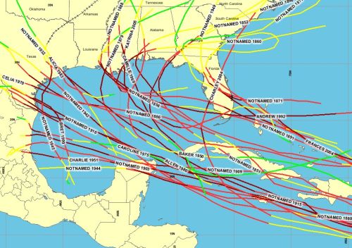
Galveston, Texas in the Gulf of Mexico has the highest rate of hurricane activity than anywhere else in the USA. The Gulf area reports more hurricane activity than any other part of the US.
The chances that a 15-inch rainfall might hit Central Texas in any given year have long been about 1-in-1,000. But with the warming of air that scientists expect over the century, some predict those chances might jump to 1-in-50.Kerry Emanuel, a prominent Massachusetts Institute of Technology meteorology professor, will lecture on the topic in Austin on Tuesday. The talk, titled “Hurricanes in the Gulf of Mexico: The History and Future of the Texas Coast,” is free and open to the public, part of the University of Texas’ Hot Science-Cool Talks series.
“We expect hurricane-related rainfall is going to get worse over next 100 years,” Emanuel said in an interview.
While that news might seem welcome in drought-stricken Central Texas — especially since moister, hurricane rain-saturated soils are likely to Read more…
Atlantic Hurricane Forecast: Storms Close to the Coast
 Astronaut, Ron Garan, snapped this photo of Hurricane Irene from aboard the International Space Station on August 22, 2011. NOAA averages are based on data from 1981-2010.
AccuWeather’s 2012 Atlantic Hurricane Season forecasts 12 named tropical storms, five named hurricanes and two major hurricanes.
The 2012 hurricane forecast is near-normal for the Atlantic Basin.
Potential Impact This Year
Predicting exactly where storms will make landfall in the U.S. would be extremely difficult, but there are some indications of areas where storms may brew and coasts that may be vulnerable based on Read more…
Saturday Tornado Recap: 100+ Tornadoes, 6 Dead
 AccuWeather.com reports tornadic thunderstorms ravaged parts of the Plains Saturday and Saturday night, killing six people and leaving behind incredible destruction.
According to the Storm Prediction Center, over 100 tornadoes were reported from Oklahoma through Kansas, Nebraska and southern Iowa on Saturday.
The deadliest of the tornadoes ravaged the town of Woodward, Oklahoma, where six people were killed and 30 injured.
The tornado ripped through the northwest side of the city, destroying or damaging dozens of homes.
Another tornado tore through the southern portion of Wichita, Kan., causing significant damage but no major injuries.
Wichita, Mid-Continent Airport recorded a wind gust of 84 mph just after the control tower evacuated.
Damage was recorded at the Boeing and Spirit Aerosystems plants. Six buildings at Spirit Aerosystems were heavily damaged while four others had major damage.
According to the Kansas City Star, damage in the Wichita area is estimated at as much as $283 million.
A tornado ripped through the town of Thurman, Iowa, Read more…
‘Very unusual’ start to tornado season

18 Wheelers thrown into the air in Dallas
Tornado season is only just beginning, but already this year has seen dozens of destructive twisters from Illinois to Texas, where up to 18 might have touched town on Tuesday alone in the Dallas-Fort Worth area.
The numbers show just how unusual: March saw 223 twisters, up from an average of 80 from 1991-2010, according to the National Weather Service. February saw 63, compared to an average of 29; and January saw 97, compared to an average of 35.
So what’s behind the outbreak?
“We’ve had record heat,” weather.com meteorologist Greg Forbes told TODAY, and “that warmth is a big ingredient that provides the instability for the storms.”
Last year started off slowly but then saw a record 758 tornadoes in April 2011, noted Roker. “Hopefully we’re not on track for that this year.”
U.S. forecasters have predicted a Read more…
Major storms set to increase
by Kate Taylor
So-called ‘storms of the century’ like last August’s Hurricane Irene could become almost commonplace, thanks to climate change.
 A team from MIT and Princeton University says that such storms could make landfall far more frequently, causing powerful, devastating storm surges every three to 20 years.
The group simulated tens of thousands of storms under different climate conditions, and concluded that the sort of severe floods which now hit every five hundred years or so could, with climate change, start happening once every 25 to 240 years.
MIT postdoc Ning Lin says that planners should take the findings into account when designing seawalls and other protective structures.
“When you design your buildings or dams or structures on the coast, you have to know how high your seawall has to be,” Lin says. “You have to decide whether to build a seawall to prevent being flooded every 20 years.”
To simulate present and future storm activity, using New York City as a case study, the researchers combined four Read more…
Floods create ‘inland sea’ in Australia

The deluge, which has sparked dozens of rescues and left about 7,275 people isolated in various parts of New South Wales state has also impacted Queensland to the north where homes have reportedly been inundated.
“From the air it looks like an inland sea,” New South Wales Premier Barry O’Farrell said after visiting the region.
Evacuations have been ordered from some houses and businesses in the New South Wales town of Moree, where more than 600 people have registered with an evacuation shelter as the Mehi River peaked, the State Emergency Service said.
“The town of Moree is inundated with water — so north Moree is not only cut off, but Read more…
Fourth person hit by lightning
 Ross Cox © Enlarge photo
Update, 4.45pm: A fourth person has been struck by lightning, after a severe thunderstorm swept over the city this morning.
The storm ripped through the south metro area this morning, causing havoc with the power supply, bringing down branches and causing minor flooding.
A warning was issued for the Perth metro area as the storm shifted north.
People in areas bound by Lancelin, Northam and Narrogin were told to prepare for damaging winds, heavy rainfall and possible hail.
Multiple thunderstorms are expected to hit Perth this afternoon following intense lightning early this morning.
There were just over 8300 lightning strikes between 12am to 2:30pm within a 600km radius of Perth yesterday, according to local weather-watcher Tom Marsh, who uploads minute-to minute updates at www.tkup.net from his Floreat weather station.
The peak rate was 95 strikes a minute at 7.14am, including strikes between clouds as well as from clouds to ground, he said.
Weather bureau forecaster Nadine Baillard said while the storms were easing off for now, higher temperatures would see them build up again this afternoon.
One person was hit by lightning at 4am on Wyeree Road in Mandurah and was taken to Peel Health Campus and a second person was struck at 4:30am on Brennan Promenade in Baldivis. He was taken to Rockingham Hospital.
A third person was taken to hospital by ambulance after he was struck at about 9am.
The 42-year-old man was working at Hertz in Welshpool when the whole office reported hearing a massive crack from Read more…
More than a million evacuated in Japan as Typhoon Roke nears

Typhoon Roke – the 15th Pacific storm of the season – was expected to make landfall in central Japan today, before moving in a northeasterly direction across the country, and possibly passing near the damaged Fukushima nuclear power plant.
The storm arrives just weeks after another typhoon swept across Japan leaving more than 90 people dead or missing and causing widespread flooding, mudslides and structural damage.
This time, about 1.1 million people in the industrial city of Nagaya in central Japan’s Aichi prefecture were urged to evacuate as the storm approached, with wind gusts of up to 134 mph.
Nagoya officials also called the Self-Defence Forces to send in troops for disaster prevention amid growing fears of Read more…
Before Hurricane Irene hits, New York planning to shut down transportation system, evacuate areas
 Astronaut Ron Garan tweeted this picture of Hurricane Irene from the International Space Station (NASA)The city is planning to shut down the entire transportation system on Saturday in anticipation of Hurricane Irene‘s arrival, officials revealed Thursday.
A mandatory evacuation of all nursing homes in flood-prone areas of the city was also ordered Thursday.
The monster storm is expected hit New York as a Category 1 storm sometime Sunday, barreling in with winds of 90 miles-per-hour and torrential rains.
Mayor Bloomberg said Thursday that it was “very conceivable” that he will order a mandatory evacuation of all low-lying areas of the city by Saturday.
“The storm is predicted to be very dangerous,” the mayor said.
As the storm finished ravaging the Bahamas Thursday and set its Read more…

![[Most Recent Quotes from www.kitco.com]](https://i0.wp.com/www.kitconet.com/charts/metals/gold/t24_au_en_usoz_2.gif)
![[Most Recent Quotes from www.kitco.com]](https://i0.wp.com/www.kitconet.com/charts/metals/silver/t24_ag_en_usoz_2.gif)


You must be logged in to post a comment.