Archive
Super typhoon Haiyan just broke all scientific intensity scales

Writing for Quartz, meteorologist Eric Holthaus says that the super typhoon Haiyan about to hit the Philippines is the worst storm he has ever seen. With sustained winds of 190mph (305km/h) and staggering gusts of 230mph (370km/h), its “intensity has actually ticked slightly above the maximum to 8.1 on an 8.0 scale.” Updated: It broke 235mph. Videos of the impact added.
Holthaus says that Yolanda—its Filipino name—beats “Wilma (2005) in intensity by 5mph—that was the strongest storm ever in the Atlantic,” which makes it a member of the select club of Worst Storms Ever in the Planet. Only three other storms since 1969 have reached this intensity.
That’s certainly foreboding enough, but the humanitarian disaster that may Read more…
Typhoon Sanba With 170-mph Winds to Threaten Japan
 Satellite image of Super Typhoon Sanba Friday afternoon, local time, Sept. 14, 2012, is from the Joint Typhoon Warning Center (JTWC).
Super Typhoon Sanba poses a growing threat to southwestern Japan and South Korea.
As of Friday evening, local time, Sanba remains a super typhoon, the equivalent of a Category 5 hurricane, according to The Joint Typhoon Warning Center (JTWC). A super typhoon is a storm with maximum sustained winds of 150 mph or higher.
The Japan Meteorological Agency estimates Sanba’s central pressure to fall to 26.58 inches (900 mb), which would allow Sanba’s strength to rank in between Hurricane Rita and Hurricane Katrina from the Atlantic. Only one typhoon in the western Pacific, Super Typhoon Megi, had a lower pressure in the past 10 years.
Sanba’s movement to the north and northwest is expected to continue through at least Saturday.
The projected path brings Sanba close to Okinawa, Japan, by Saturday night, local time. While the island is well-prepared for typhoons, damage, power outages and flooding are likely.
“It will be a life-threatening situation for the Read more…
Climate change causing increase in extreme weather in South Pacific
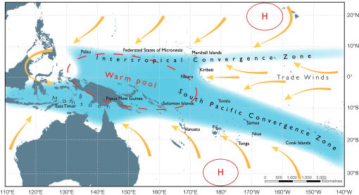
An international study led by CSIRO oceanographer Dr Wenju Cai has identified that global warming is causing shifts in the rain band of the South Pacific Convergence Zone causing an increase in extreme weather across the island nation states of the South Pacific. The result of the movement causes drought and higher prevalence of forest fire in some areas while other islands experience extreme floods and increased frequency of tropical cyclones.
The South Pacific Convergence Zone is the important rainband that stretches from the equatorial western Pacific southeastward toward French Polynesia. When the rainband moves northward, extreme climate events are induced. “Here we show that greenhouse warming Read more…
Major storms set to increase
by Kate Taylor
So-called ‘storms of the century’ like last August’s Hurricane Irene could become almost commonplace, thanks to climate change.
 A team from MIT and Princeton University says that such storms could make landfall far more frequently, causing powerful, devastating storm surges every three to 20 years.
The group simulated tens of thousands of storms under different climate conditions, and concluded that the sort of severe floods which now hit every five hundred years or so could, with climate change, start happening once every 25 to 240 years.
MIT postdoc Ning Lin says that planners should take the findings into account when designing seawalls and other protective structures.
“When you design your buildings or dams or structures on the coast, you have to know how high your seawall has to be,” Lin says. “You have to decide whether to build a seawall to prevent being flooded every 20 years.”
To simulate present and future storm activity, using New York City as a case study, the researchers combined four Read more…
More than a million evacuated in Japan as Typhoon Roke nears

Typhoon Roke – the 15th Pacific storm of the season – was expected to make landfall in central Japan today, before moving in a northeasterly direction across the country, and possibly passing near the damaged Fukushima nuclear power plant.
The storm arrives just weeks after another typhoon swept across Japan leaving more than 90 people dead or missing and causing widespread flooding, mudslides and structural damage.
This time, about 1.1 million people in the industrial city of Nagaya in central Japan’s Aichi prefecture were urged to evacuate as the storm approached, with wind gusts of up to 134 mph.
Nagoya officials also called the Self-Defence Forces to send in troops for disaster prevention amid growing fears of Read more…
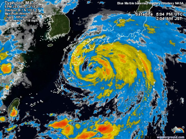
Typhoon Ma-on approaches Japan
Typhoon Ma-on is threatening the Japanese island of Shikoku. According to forecasters, the typhoon is likely to make landfall on Wakayama Prefecture (Honshu Island) early on July 20th. Later on Wednesday, July 20th or early on Thursday, July 21st, the typhoon, weakened by that time into a category-one storm, is expected to hit the south of Kanto Plain and Tokyo-Yokohama metropolitan area. Consequently, heavy downpours and strong winds are forecast while flash floods and landslides remain possible. Power cuts, telecommunication and water outages are possible in affected areas. Transport disruptions are also expected as the typhoon could force the closure of several airports including Osaka International airport, Tokyo International Airport (Haneda) and Narita International Airport. Ferry and train services (including the high-speed trains Shinkansen) are likely to be disrupted in southern and central Honshu.
Typhoon Ma-on will generate heavy Read more…


![[Most Recent Quotes from www.kitco.com]](https://i0.wp.com/www.kitconet.com/charts/metals/gold/t24_au_en_usoz_2.gif)
![[Most Recent Quotes from www.kitco.com]](https://i0.wp.com/www.kitconet.com/charts/metals/silver/t24_ag_en_usoz_2.gif)

You must be logged in to post a comment.