Archive
Quake felt across central New Zealand

LATEST: A deep earthquake measuring 6.5 has been widely felt across the lower North Island, but there were no initial reports of damage.
GNS Science said the earthquake was a magnitude 6.5, centred 150km deep, 30km west of Taupo. It struck at 3.36pm.
Initial reports on GNS’ website show the quake was felt in Wellington, Nelson, New Plymouth and up to the Coromandel.
GNS volcanologist Brad Scott said although the earthquake was centred near Taupo it was more likely felt on Read more…
Is the Massive Puerto Rico Trench Awakening?
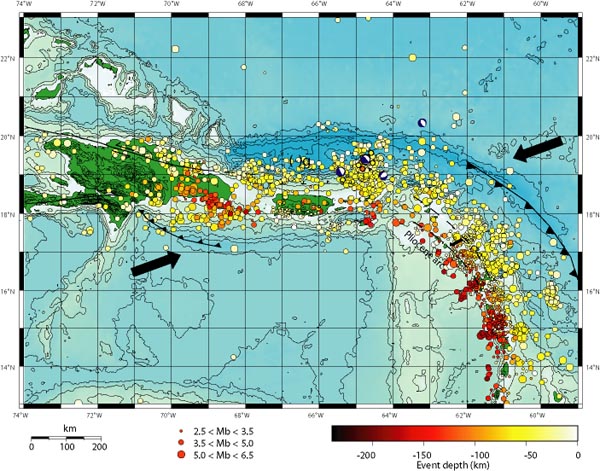
by Zen Gardner
“What Puerto Rico Trench?” Exactly.
The arrows in the map above show the direction the underlying Caribbean tectonic plates are moving, with the resultant build-up of pressure releasing into a myrid of earthquakes in the region over the years. Puerto Rico is the smaller green island in the middle, with the Dominican Republic the larger island to the left. The string of other Caribbean islands is buried under the earthquake markers that Read more…
Indonesia Hit By Strong Earthquake, Latest On Ring Of Fire

Indonesia was hit by a large earthquake and a series of strong tremors Sunday afternoon. A 6.5 magnitude quake, the latest in string of strong quakes to hit the Pacific Ring if Fire region during the last week, struck the country’s easternmost Province of Papua 1.16 p.m. GMT.
The quake was centred 53 kilometres (33 miles) northeast of Waren, a town on the northern coast of Papua island, according to Indonesia’s Meteorology and Geophysics Agency. It was also felt in nearby Biak island, and Enarotali town on the main island The U.S. Geological Survey put the initial quake’s magnitude at 6.4.
The region was hit by at least moderate tremors in the following hours. The tremors measured 5.4 (x2), 5, 4.5 and 4.3 on the Richter Scale. There were no immediate reports of damage and no tsunami warning was issued.
Papua comprises most of the Read more…
Case Study: Tsunami in Seaside, Oregon
Oregon Coast’s Vulnerability
 Recent research suggests that a Cascadia Subduction Zone earthquake could create tsunami waves that impact over 1,000-km of coastline in the U.S. and Canada. Source: USGS
The northwestern coast of Oregon is susceptible to both local and far-field tsunamis. The Cascadia Subduction Zone, where the eastward moving Juan de Fuca plate meets the westward moving North American Plate, is just off the Pacific Northwest coast of the United States and Canada. It is a 750-kilometer long fault zone. This area is very active tectonically, and therefore has the potential to produce large earthquakes and possibly, subsequent tsunamis. This subduction zone is thought to have last ruptured in 1700.
Additionally, far-field earthquakes throughout the Pacific are also capable of spawning tsunamis that could eventually reach the Oregon coast. Historical records show that since 1812, about 28 tsunamis with wave heights greater than one meter have reached the U.S. west coast. The March 1964 “Good Friday” earthquake created the most devastating of these tsunamis. The epicenter of this earthquake was near Anchorage, Alaska. The tsunami that followed this earthquake reached coasts all along the western U.S. within six hours. Cannon Beach, a small coastal community in northwestern Oregon was inundated during Read more…
Tectonic plates rattle- more turbulence at the South Pole
 USGS")
June 21, 2011 – ANTARCTICA – A 5.5 magnitude earthquake struck the South Sandwich Islands region, situated around 750km south east of South Georgia, in the South Atlantic early Sunday. It was the latest in a series of quakes to hit the Antarctic Region during the past 24 hours. The moderate quake struck at 9.37am GMT at a depth of 137km and was centered 69 km (42 miles) NNW of Visokoi Island and 330 km (205 miles) NNW of Bristol Island. The last significant earthquake to be recorded in the South Sandwich Islands region occurred on Read more…
Number Of Recorded Earthquakes Rises Sharply

2011 is on target to record the largest number of earthquakes in a single year for at least 12 years.
Research by Irish Weather Online, using data from the US Geological Survey (USGS), has found that earthquake activity (5.0-9.9 magnitude) from 01 January to 19 June 2011 is already exceeding the total annual seismic activity for the years 2001, 2002 and 2003. 2011’s total number of recorded earthquakes is also expected to exceed the most seismically active year of the past 12 years, 2007.
A total of 1,445 earthquakes, ranging in magnitude from 5.0 to 9.9, have been recorded in the year up to 19 June. The total number of earthquakes recorded globally for the entire of 2007 was 2,270.
The massive earthquakes in Japan (2011), Chile (2010), Sichuan (2008), Sumatra (2005 and 2008) and Indonesia (2004) have served to remind us of the devastating impact of earthquakes on life and property. While the number of earthquakes ranging Read more…
‘Dramatic’ solar flare could disrupt Earth communications
Handout photo released by NASA Earth Observatory on June 7, 2011 and taken from NASA’s Solar Dynamics Observatory (SDO), sunspot complex 1226-1227, shows the Sun unleashing an M-2 (medium-sized) solar flare.
WASHINGTON – An unusual solar flare observed by a NASA space observatory on Tuesday could cause some disruptions to satellite communications and power on Earth over the next day or so, officials said.
The potent blast from the Sun unleashed a firestorm of radiation on a level not witnessed since 2006, and will likely lead to moderate geomagnetic storm activity by Wednesday, according to the National Weather Service.
“This one was rather dramatic,” said Bill Murtagh, program coordinator at the NWS’s Space Weather Prediction Center, describing the M-2 (medium-sized) solar flare that peaked at 1:41 a.m. Eastern time in North America, or 0541 GMT.
“We saw the initial flare occurring and Read more…
Something Strange With Volcano Eruption in Chile

What appears to be an enormous ash cloud rising from the eruption of a long dormant volcano named Puyehue in southern Chile on June 4, 2011, isn’t quite matching up with the location of the recorded earthquakes today in the immediate area.
“The Cordon Caulle (volcanic range) has entered an eruptive process, with an explosion resulting in a 10-kilometer-high gas column,” Chilean state emergency office said.
The thing is, for some unknown reason, as of this writing, eight earthquakes near magnitude 5 have shook the earth near the Puyehue volcano. The problem is, the earthquakes are located 20 to 40 miles away from the eruption! Very Strange Indeed. (Strange because one would think that Read more…
115 quakes recorded at Taal volcano in 24 hours

MANILA, Philippines— (UPDATE) Taal Volcano was rocked by 115 earthquakes in the past 24 hours, the highest number of tremors recorded in the area since the Philippine Institute of Volcanology and Seismology placed the restive volcano under Alert Level 2 last April.
It was the highest number in a day, a jump from the average of 10 mild quakes daily since alert level 2 (increasing restiveness) was hoisted over Taal on April 9, said Jaime Sincioco, officer-in-charge of the Volcano Monitoring and Eruption Prediction Division of Phivolcs, in a phone interview.
He said that in the series of the 115 volcanic quakes recorded up to 3 a.m. Monday, 12 were of intensity 1 to 4 and “were felt by the residents” on the volcano island.
The strongest quake, also since April 9, was felt at intensity 4 at around 1:05 a.m.
Phivolcs said residents around the volcano in Taal, Batangas heard rumbling Read more…

![[Most Recent Quotes from www.kitco.com]](https://i0.wp.com/www.kitconet.com/charts/metals/gold/t24_au_en_usoz_2.gif)
![[Most Recent Quotes from www.kitco.com]](https://i0.wp.com/www.kitconet.com/charts/metals/silver/t24_ag_en_usoz_2.gif)


You must be logged in to post a comment.