Archive

Posts Tagged ‘weather’

Drought and wildfire threaten America’s cattle capital

July 21, 2011 1 comment

csmonitor

* A mother and her calf idle in dead grassland on the Swenson Ranch outside Stamford, Texas, in this photo from May 21. Severe drought and millions of acres of wildfires have delivered a potent one-two punch this year, forcing tough decisions on ranchers across cattle country. Elliott Blackburn / Reuters /. File

Chicago-As if the heartland hasn’t faced enough this summer, with wildfires, droughts, and punishing heat, cattle ranchers are now facing a hay shortage.

The triple-digit temperatures, expected to result in the worst drought north-central Texas has ever experienced, follows spring wildfires, which scorched millions of acres that traditionally nourish the nation’s largest steer population – five million head of cattle.

Most Texas pasture and range lands – 86 percent – are currently “poor” or “very poor,” according to the US Department of Agriculture’s National Agricultural Statistics Service. The same rating applied to 69 percent of Oklahoma and 40 percent of Kansas.

The hardships this year “don’t compare to any in recent years,” says Jason Miller, a county agriculture agent for the Texas AgriLife Extension Service (TALES). “The ranchers are just holding on.”

July temperatures have topped 110 degrees in the heart of cattle country, from Texas to Kansas. Ranchers complain that Read more…

Heat Warnings Issues in 17 States

July 19, 2011 Comments off
christianpost

The majority of the U.S. is in for another sweat dripping next few days as this weekend’s heat wave lingers into the work week.

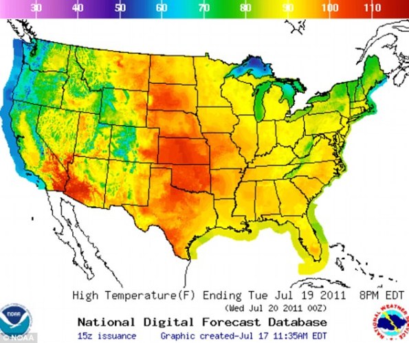
The heat index is as high as 126 degrees in portions of the upper Midwest. Heat warnings, watches, and advisories remain in effect for most of central U.S. Seventeen states have issued heat warnings for this week and 36 states are expected to see 90 degrees or above today.

The Midlands are expected to see heat index values between 110-115 between Thursday through Sunday of this week. Air temperatures will likely break records and by Wednesday the midlands are expected to be at or around the century high mark.

According to Accuweather, a high pressure system over the Great Plains is the cause for sizzling temperatures from Texas through the Midwest. The plains and Mississippi Valley are likely to feel the worst of the Read more…

Typhoon Ma-on approaches Japan

July 18, 2011 Comments off

netglobers

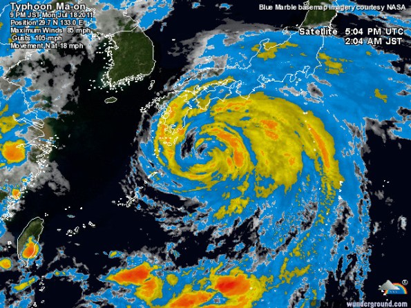
Typhoon Ma-on is threatening the Japanese island of Shikoku. According to forecasters, the typhoon is likely to make landfall on Wakayama Prefecture (Honshu Island) early on July 20th. Later on Wednesday, July 20th or early on Thursday, July 21st, the typhoon, weakened by that time into a category-one storm, is expected to hit the south of Kanto Plain and Tokyo-Yokohama metropolitan area. Consequently, heavy downpours and strong winds are forecast while flash floods and landslides remain possible. Power cuts, telecommunication and water outages are possible in affected areas. Transport disruptions are also expected as the typhoon could force the closure of several airports including Osaka International airport, Tokyo International Airport (Haneda) and Narita International Airport. Ferry and train services (including the high-speed trains Shinkansen) are likely to be disrupted in southern and central Honshu.

Typhoon Ma-on will generate heavy Read more…

Global temperatures were seventh warmest on record for June

July 18, 2011 Comments off

noaa

The globe experienced the seventh warmest June since record keeping began in 1880. The Arctic sea ice extent was the second smallest extent for June on record.

The monthly analysis from NOAA’s National Climatic Data Center is part of the suite of climate services NOAA provides government, business and community leaders so they can make informed decisions.

Global Temperature Highlights:  June

  • The combined global land and ocean average surface temperature for June 2011 was the seventh warmest on record at 60.94 F (16.08 C), which is 1.04 F (0.58 C) above the 20th century average of 59.9 F (15.5 C). The margin of error associated with this temperature is +/- 0.13 F (0.07 C).
  • Separately, the global land surface temperature was 1.60 F (0.89 C) above the 20th century average of 55.9 F (13.3 C), which was the fourth warmest June on record. The margin of error is +/- 0.23 F (0.13 C). Warmer-than-average conditions occurred across most of Russia, Europe, and China, the Middle East, eastern Canada, Mexico, and the southern United States. Cooler-than-average regions included the northern and western United States, part of western Canada, and most of Australia.
  • The June global ocean surface temperature was 0.85 F (0.47 C) above the 20th century average of 61.5 F (16.4 C), making it the Read more…

Record Heat stories US and the world

June 2, 2011 Comments off
Categories: Earth, Weather Tags:

Destructive tornadoes sweep through Massachusetts, kill 4

June 2, 2011 Comments off

freep.com

A child runs for cover as bad weather returns to Springfield, Mass., after a tornado touched down Wednesday. Gov. Deval Patrick declared a state of emergency and called up 1,000 National Guard troops.

 A child runs for cover as bad weather returns to Springfield, Mass., after a tornado touched down Wednesday. Gov. Deval Patrick declared a state of emergency and called up 1,000 National Guard troops. / DON TREEGER/(Springfield, Mass.) Republican via As

SPRINGFIELD, Mass. — Tornadoes roared through Massachusetts on Wednesday as violent winds caused damage in about two dozen communities, ripping off roofs, uprooting trees, scattering debris and leaving at least four dead throughout the state.

The governor said the death toll was preliminary.

The storm pulverized or sheared off the tops of roofs on Main Street in Springfield, a city of more than 150,000 about 90 miles west of Boston. A mounted video camera captured dramatic footage of a debris-filled funnel as it swept into downtown from the west, then crossed the Connecticut River.

Gov. Deval Patrick declared a state of emergency and Read more…

Super Typhoon Songda Projected To Pass Over Fukushima Nuclear Power Plant

May 27, 2011 Comments off

zerohedge

So far the only good news to accompany the Fukushima catastrophe has been that for all the fallout, the radiation has been mostly contained due to Northwesterly winds which have been blowing any radioactivity mostly out and into the Pacific (coupled with relatively little rainfall), as well as the dispersion of irradiated cooling water which promptly enters the Pacific after which it is never heard of or seen again (there is at least a several year period before 3 eyed tuna fish feature prominently in restaurants across the country). This may be changing soon now that Super Typhoon Songda, which according to Weather Underground will form shortly as a Category 5 storm with 156+ mph winds, will take a northeasterly direction and 2 days later will pass right above Fukushima. The good news: by the time it passes over Fukushima, Songda will be merely a Tropical storm. The bad news: by the time it passes over Fukushima, Songda will be a Tropical storm. As the latest dispersion projection from ZAMG shows, over the next two days the I-131 plume will be covering all of the mainland. Although judging by how prominent this whole topic is in the MSM lately, it seems that conventional wisdom now agrees with Ann Coulter that radioactivity is actually quite good for you.

From wunderground.com:

And the latest plume projection: Read more…

Fierce forecast: Feds predict up to 10 Atlantic hurricanes in 2011

May 19, 2011 Comments off

usatoday

Federal forecasters Thursday called for an “above-normal” hurricane season this year. They predict anywhere from 12-18 named storms to form in the Atlantic Ocean, Caribbean Sea and Gulf of Mexico.

Hurricane Earl spins in the Atlantic Ocean last September. Although it didn't make landfall, Earl came the closest to hitting the USA of any 2010 hurricane.Hurricane Earl spins in the Atlantic Ocean last September. Although it didn’t make landfall, Earl came the closest to hitting the USA of any 2010 hurricane.

Of those named storms, six to 10 should become hurricanes, including three to six “major” hurricanes, with wind speeds above 111 mph.

Tropical storms are given a name when wind speeds reach 39 mph. They are upgraded to hurricane status when their sustained winds reach 74 mph. An average Atlantic hurricane season sees 11 named storms, including six hurricanes; two become major hurricanes.

Forecasters do not predict the number of storms that will make landfall.

Climate factors in this outlook include unusually warm Atlantic Ocean water and temperatures two degrees above average, reports Gerry Bell, lead seasonal forecaster at the Climate Prediction Center. Additionally, the impacts of the La Nina climate pattern, such as reduced wind shear, are expected to continue into the hurricane season.

“In addition to multiple climate factors, seasonal climate models also indicate an above-normal season is likely, and even suggest we could see activity comparable to some of the active seasons since 1995,” Bell said.

Since 1995, Bell says the Atlantic is in an era of increased hurricane activity. There are consistently favorable ocean and atmospheric conditions for storm formation.

Thursday’s NOAA forecast is similar to earlier predictions by researchers at Colorado State University and the AccuWeather commercial weather service. The Colorado State team, led by Read more…

Multiple vortex forming over Northern America

May 11, 2011 4 comments

thewatchers

There is an upper level low pressure system vortex storm forming of East Coast of US. It’s an occluded front with a low pressure of 29.29hg or 992mb. The winds are rotating the system counterclockwise. In previous post we gave some possible explanation of the situation and we gave some notes about polar cyclones, arctic storms, nor’eastern storms and explanation of Coriolis effect. The upper level low pressure systems are important to forecasting and can...

There is an upper level low pressure system vortex storm forming of East Coast of US. It’s an occluded front with a low pressure of 29.29hg or 992mb. The winds are rotating the system counterclockwise. In previous post we gave some possible explanation of the situation and we gave some notes about polar cyclones, arctic storms, nor’eastern storms and explanation of Coriolis effect.

The upper level low pressure systems are important to forecasting and can dramatically alter one’s forecast. Upper level lows can occur in association with a mid-latitude cyclone or may begin without the aid of a mid-latitude cyclone. Upper level lows without the aid of a surface low can develop when air flows over a mountain range, in association with an upper level short wave, or in Read more…

Record wildlife die-offs reported in Northern Rockies

May 9, 2011 Comments off

msnbc

SALMON, Idaho — A record number of big-game animals perished this winter in parts of Montana, Idaho and Wyoming from a harsh season of unusually heavy snows and sustained cold in the Northern Rockies, state wildlife managers say.

“Elk, deer and moose — those animals are having a pretty tough time,” said Wyoming Game and Fish biologist Doug Brimeyer.

Snow and frigid temperatures in pockets of Idaho, Montana and Wyoming arrived earlier and lingered longer than usual, extending the time that wildlife were forced to forage on low reserves for scarce food, leading more of them to starve.

Based on aerial surveys of big-game herds and signals from radio-collared animals, experts are documenting high mortality among offspring of mule deer, white-tailed deer and pronghorn antelope.

This comes as big-game animals enter the last stretch of a period from mid-March through early May that is considered critical for survival.

Wildlife managers estimate die-offs in the tens of thousands across thousands of square miles that span prairie in northeastern Read more…